March 29, 2009

Dong kids doing what they do best-play at Chengyang, Guangxi

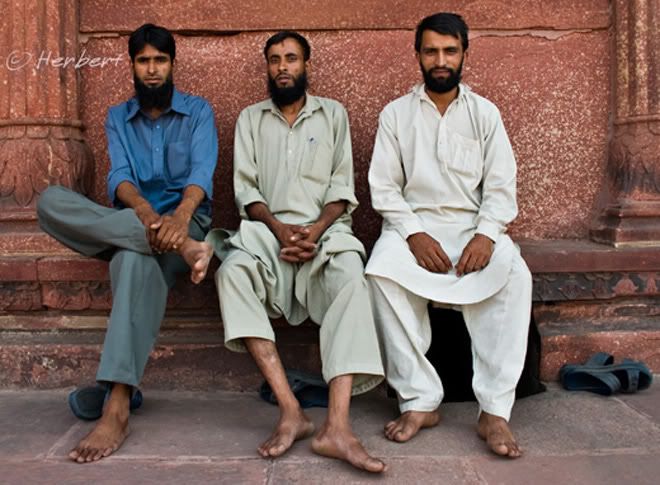
Locations: Chengyang, Guangxi, China ( 25° 54' 19" N, 109° 39' 17" E)
Date: 16 April 2005; 4.20pm
Camera: Canon Ixus IZoom

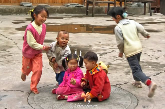
Chengyang is a traditional village of the Dong minority in Guangxi. It is well-known for its Wind and Rain Bridge and Drum Towers. As is traditional in such ancient Dong villages, there are also a couple of places where the community would gather in the village such as open-air opera house. When there are no gatherings or events in these places, they became the playground for the kids. There are hundreds of Wind and Rain Bridges in Guangxi as virtually every Dong village would have one. Chengyang's is one of the finest, most elaborate and well-preserved and was built in 1916. It is a popular tourist destination for visitors in this part of the province. It is so popular that the village is "poisoned" by its popularity. Instead of being the usual hospitable, warm and friendly Dong village (I have been to many and all of them are very, very friendly and warm), most of its residents only see dollar (oops, I mean Yuan) sign in their dealings with outsiders. Money is demanded from any outsiders who want to take a photo of the residents (adults demand it on behalf of kids), their houses or even walk into a public area such as this opera house compound! It was one of my most disgusted experiences in rural China.

Read More...

March 25, 2009

Giant walls of limestone islands, Phang Nga Bay, Thailand

Location: Phang Nga Bay, Thailand (8° 17′ 0″ N, 98° 36′ 0″ E)
Date: 6 March 2009; 11.15am
Camera: Canon IXUS IZoom

Phuket is one of the most popular destinations in Thailand especially during the northern winter. It is especially popular among Europeans; so much so that everything- and I mean everything- on the island is expensive, even more than a place like Singapore! It is a beach-lover paradise but one of the best activities to do is to go on a canoe trip to the Phang Nga Bay.

Phang Nga Bay is a little like Halong Bay of Vietnam, studded by limestone karsts, some of which are hundreds of meters tall, protruding out from the sea. Some of these are virtually little isolated islands with collapsed cave systems and steep walls. Some of the islands have hongs, tidal sink holes in the middle of rock islands, connected to the sea by narrow caves. Inside, these hongs are mysteriously open to the sky, and harbour a world that has remained hidden from humans since their creation, thousands of years ago. Kayaking into these hongs and enjoying the tranquility should be one of the "must-do's" of Thailand.

Technorati Tags: ,,

Read More...

March 23, 2009

Bamboo rafts on the 9 Twists River of WuYiShan, Fujian, China

Location: WuYiShan, Fujian, China (27° 40′ 0″ N, 117° 45′ 0″ E)
Date: 12 December 2007, 3.30pm

Camera: Canon 400D with Sigma 17-70/f2.8-4.5

WuYiShan is an UNESCO site for its large well-preserved subtropical native forests. It is dotted with many sheer rock peeks that just seem to jut vertically skywards, caves and a clear emerald river meandering in its midst. Its UNESCO status is also awarded for its historical and cultural heritage, with remains of a 2,000 years old city, cliff-side sculptured calligraphies and the home and an academy established by a renowned Song Dynasty philosopher. It is worth spending a day or two exploring the scenic area as there are many opportunities to explore and hike in the back mountains, away from the major tourist routes. This area is a major tea plantation area with its unique tea species and so there are always few villagers tending to their plots during the day; therefore it is easy to ask for directions if one speaks Chinese. In fact it is NOT difficult to avoid paying the entrance fee by entering the park by hiking the hills. However the best panoramas and viewpoints are to be found in the main tourist routes

Read More...

March 20, 2009

Monument dedicated to Peace in 32 languages near Eiffel Tower

Location: Wall for Peace near Eiffel Tower, Paris, France, (48° 51′ 29.88″ N, 2° 17′ 40.2″ E)
Date: 1 March 2006; 12.10pm
Camera: Canon 300D with Sigma 70-200/f2.8

The Wall of Peace is a glass and metal monument to peace is located at the foot of the Eiffel Tower on the Parc du Champs de Mars. The glass features the word "peace" written in 32 languages and 18 alphabets. Visitors are allowed to put their own messages in the chinks of the wall. The monument erected on 30 March 2000 was supposedly meant to stay for only four months and then moved to other Paris neighbourhoods. However it never did, to the chagrin of nearby neighbourhood residents who complained that it spoils the view. Personally I thought it was a cool and meaningful addition to the attraction.

Read More...

March 18, 2009

Nightscape of Melbourne along the Yarra River

Location: Yarra River, Melbourne, Victoria, Australia (37° 49′ 5.08″ S, 144° 58′ 0.52″ E)
Date: 20 May 2008, 8.10pm
Camera: Canon 400D with Sigma 17-70/f2.8-4.5

The Yarra River runs right through Melbourne, the capital of Victoria State. The river is the focal point of outdoor activities and events as well as the concentration of its skyscrapers at Federation Square. Immediately next to it is the city's central railway station, Flinders Street Station right beside the river. The station built in 1864 and expanded over the years covers two city blocks. The Southbank across the river from the station is a pleasant place to walk in the evening with great night views of the city lights. Melbourne, as with most, if not all of Australasian cities, is a safe city to wonder around alone at night.

Read More...

March 16, 2009

Typical scenery in Ngaungshwe villages, Myanmar

Location: Nyaung Shwe, Myanmar (20°39′N 96°56′E)
Date: 19 December 2000; 3.15pm
Canon EOS 500N (analogue) on slides and scanned

Nyaungshwe is a small village north of Lake Inle of Myanmar and is the hub to visit the lake and surrounds. When I visited the village in 2000, it was a very small place of a couple of thousand people, no more. I am sure it has grown a lot now with Lake Inle being a major tourist destination in Myanmar now. It was a village with farming as the major activity then. The village is very much a water-borne village and the main mode of transport is by boats. The people are extremely friendly as is the most of Myanmar. Ordinary Myanmese who speaks English are very keen to engage foreigners in conversation to learn about the outside world and what they know and think of their country; this is because generally they are shut out of the world by one of the most repressive military dictatorship/regime in the world. As was discussed in one of my earlier post, I have no love for the Myanmar military junta but do not support tourism boycott of the country.

Read More...

March 12, 2009

Beautiful Hanas Lake, Xinjiang in autumn

Locations: Hanas Lake, Xinjiang, China (48°43'20.23"N 87° 1'26.07"E)
Date: 19 June 2004; 12.25pm

Camera: Canon 300D with kit lens

Xinjiang is the biggest province in China. As such it has a vast variety of landscape with dry, arid desert (such as Taklamakan, the 2nd biggest desert in the world) predominating. However there are no shortage of lofty snow peaks and beautiful alpine lakes. The longest mountain range in the world, the Kunlun slash across the province while the deserts of the west stops at the foothills of the snowy Pamirs. In the north, bordering Russia and Mongolia is the magnificent Altay range, one of the most beautiful ranges of mountain in China. Lake Hanas nestles near this range. This region is mainly inhabited by Kazakhs and Mongols. The lake is especially pretty in the autumn when the forests burst into a rage of yellow, red and orange. Together with a nearby village, Hemu, these locations had become a photographer's Mecca in the autumn.

Technorati Tags: ,,,

Read More...

March 7, 2009

Yangshuo, China- the changing face (Part 3)

Location: Yangshuo, Guangxi, China (24° 47′ 0″ N, 110° 30′ 0″ E)
Date: 30 April 2002, 12.40pm
Camera: Canon G1

This scenery was taken from the bridge across YuLong He, south of Yangshuo on the way to Gaotian- I am not sure of its name. Few years ago there were many local farmers who operate bamboo rafting independently along YuLongHe, especially around here; reason being this site is close to the main road and so easy to solicit passengers. The rafts used to be parked at no more than four sites around and along this stretch of the river with a couple more upstream. The river then was still pretty much undisturbed except for a couple of shallow cement crossings that are only possible when the water is low. No resorts, retreats or hotels along the river. Evenings are especially magical with beautiful twilight when all the farmers row across the river on their way to home (as In this photo).

This is all in the past. In 2008, the river banks around this part of the river have been lined with concrete with a couple of huge carparks for tourist buses. The tranquility is broken by the presence of numerous cafes, over hundred of rafts, hordes of tourists and wires hanging across the river. The banks of the river are now lined with numerous hotels and resorts while vegetation along the river has been cleared to make way for more rafting stations. The rafters are still there; but there are no longer independent operators but employees of the Singapore/Taiwanese company that has sole right to "develop" and profit from tourism activities on and along the river.

Read More...

March 5, 2009

Muslim men relaxing at Jama Masjid, Old Delhi, India

Location: Jama Masjid, Delhi, India (28° 39′ 3″ N, 77° 13′ 59″ E)
Date: 2 October 2005; 8.30am
Camera: Canon 300D with kit lens
The biggest mosque in India, Jama Masjid was built by the same emperor who built the iconic Taj Mahal, Shah Jahan around 1650. It supposedly has a capacity for 25,000 worshippers. Jama Masjid is located in the "Muslim part" of Delhi, Chandni Chowk of Old Delhi. Delhi actually has a huge Muslim population- approximately 3.4 million is about 25% of the city's total population. In fact India itself has the 2nd biggest Muslim population in the world, standing at 150 million, behind Indonesia. Generally most of the Indian Muslims are indistinguishable from Indians of other faiths (Hindus, Buddhists or Jains). Some can be identified by the way they wear their facial hair, turban or topi (skullcap).

Read More...

March 3, 2009

Medieval bridge, Ponte Vechhio over River Arno, Florence, Italy

Location: Ponte Vechhio, Florence, Italy (43° 46′ 4.76″ N, 11° 15′ 11.49″ E)
Date: 17 March 2005; 5.10pm
Camera: Canon 300D with kit lens.

The Ponte Vechhio is a Medieval bridge over the River Arno and is the oldest bridge in Florence - it was the only bridge in Florence to survive Nazi explosives in 1944. It is unique for having shops built along it, as well as having buildings lining both edges of the bridge. Originally butcher occupied these shops and buildings but these were eventually closed down as the butchers used to throw unwanted leftovers into the river thus polluting it. It is now lined with jewellers, art dealers and souvenir sellers, catering mainly to tourists. There is also a gap in the centre of the bridge between the shops, presenting tourists a great view of the river and the buildings on opposite banks.

Read More...

March 1, 2009

February Slideshow

Read More...