February 28, 2009

Lincoln and Churchill in Singapore

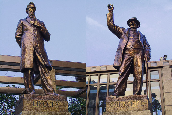
Location: Parkview Square, Singapore (1°18'0"N 103°51'27"E)
Date: 31 October 2002; 6.05pm
Camera: Canon G1

The building, Parkview Square is a landmark building in Singapore, located just outside the Central Business District. It is a landmark because it stands majestically tall in solitary in contrast to the much-shorter buildings around it. The owner wanted the building to be "imposing and monumental, yet stylish and elegant". The building is designed in the classic Art Deco style, with a similar Art Deco lobby that feature a 15m-high ceiling with handcrafted details. The open plaza, reminiscent of Piazza San Marco of Venice, is surrounded by sculptures and statues of many famous figures in world history such as the two gentlemen in the photograph, Sun Yat-sen, Mozart, Shakespeare and others. The building is also adorned with many motifs, sculptures, and ornamentation. It is "guarded" by eight gigantic fiberglass statues of men holding a light ball in their hands, four of them standing on each broad side of the building's crown. Similarly hand-crafted gargoyles decorate the building's exterior while a statue of a golden bird stands in the center of the plaza.

Read More...

February 26, 2009

Spectacular waterfall inside Endau Rompin National Park

Location: Buaya Sangkut waterfalls, Endau Rompin National Park, Malaysia (2°2′01″N, 103°19′10″E)
Date: 13 August 1995; 2.10pm

Camera: (analogue) Olympus Mu on negatives and scanned

Endau Rompin National Park straddles the states of Johor and Pahang, Malaysia. It is a huge natural reserve of lush, pristine tropical rainforest with some unique floral and fauna only found here. The park is intrinsically tied up with numerous legends and myths handed down through the years, including that of the spectacular 5-level 40 meters high and 30 meters wide, cascading waterfall named Buaya Sangkut.


One legend has it that the Jasin River and the Endau River were dwelled by thousands of dangerous crocodiles. The man-eaters often attack and endanger the people in the area who use the river. The ‘Orang Asli’ (aborigine) believed that if they could kill the crocodile king, the people will not fear the crocodiles anymore. They managed to catch the crocodile king after hunting it for some time. The crocodile king was thrown into the water at Seganggong hill, the top of the current waterfall. The crocodile was unable to move as it was trapped at the rocky hill. Finally the crocodile died and the waterfall was named "‘Buaya Sangkut" literally means "Stranded Crocodile".

Another legend was that a woman was haunted by a dream that a crocodile was coming to kill her new-born daughter. Believing that the dream was an omen, the woman and her family moved uphill to avoid this catastrophe. However the crocodile followed them. To protect their baby girl, the husband summoned a python to kill the crocodile, leading to a fierce fight ending in the death of both reptiles. Relieved at the outcome, the husband de-skinned the crocodile and hung its hide on a wall. Unfortunately a few days later, the hide fell on the daughter and killed her anyway.

Whichever legends one subscribes to, it is widely believed that the crocodile-shaped stone at the foot of the falls, which is visible when the water level is low, is the same crocodile recounted in the legends.

Read More...

February 24, 2009

Bicycle is still the King of Transport in China

Location: Chengdu, Sichuan, China, (30°37'0"N 104°5'59"E)
Date: 16 April 2003; 9.05am
Camera: Canon G1
Despite the explosion of car ownership in China especially in the major cities, bicycle is still the number one mode of transport in the country. However China's bicycle fleet is declining- it has declined by 35% from 670 million to 435 million between 1995 and 2005. Nevertheless this still dwarfs the car population estimated at around 10 million vehicles nation-wide. As such it is not surprising that Chinese are very adept at using bicycle- not only for riding from one place to another, but for bonding between family members. This boy is still half asleep while his father' lovingly send him to school in the morning.

Read More...

February 22, 2009

Porters leaving Manang, Annapurna Circuit, Nepal

Location: Manang on Annapurna Circuit, Nepal (28° 40' 0 N 84° 1' 0 E)
Date: 9 April
2000; 7.15am
Camera: Canon
EOS 500N (analogue) on slides and scanned

Manang is a popular stop for acclimatisation on the Annapurna Circuit because at 3,540m, it is just high enough to allow the body to get used to higher attitude. It also has some spectacular scenery of giant peaks, a glacier lake and the Marshyangdi River flowing in the valley. On any day, one will see many porters leaving early in the morning carrying the packs of their clients. Peculiar to Nepal and Tibet, the porters find it easier to "carry" heavy packs by putting the weight on their forehead, by a naamlo (forehead carrying strap). Life as a porter is hard- they only earned a couple of $ per day; the lucky ones will get some tips from the trekking clients at the end of the trip. I have never used a porter on my trekking in Nepal but I observed that it is extremely easy to engage porters from the villages at the head of treks such as Annapurna and/or Khumbu. There is really no need to go through middlemen to engage porters on your behalf from Kathmandu or Pokhara; not only no need but not recommended as most of the money you pay will go to the middlemen instead of rewarding the porters directly.

Read More...

February 18, 2009

The "Eye"- Pakistan truck painting

Location: Gilgit, Pakistan (35° 55' 0 N 74° 17' 60 E)
Date: 27 June 2007; 1.15pm
Camera: Canon 400D with Sigma 17-70/f2.8-4.5

Trucks in Pakistan are often painted with dazzling arrays of images in a kaleidoscope of colours. These images could be landscapes, mythical figures, religious verses, portraits or calligraphic poetry. Every panels of a truck- the sides, back, doors or front- could be adorned by such paintings. Some of these paintings are painted for luck, protection or to stand-out among the crowd. Truck painting is peculiar to Pakistan- one do not see such a phenomena in other South Asian countries such as India or Afghanistan. Such trucks are truly masterpieces on four wheels.

Read More...

February 16, 2009

Taj Mahal from across Yamuna River at sunset

Location: Taj Mahal, Agra, Uttar Pradesh, India(27° 10′ 48″ N, 78° 1′ 12″ E)
Date: 7 Jan 2009; 4.10pm
Camera: Canon 400D with Sigma 17-70/f2.8-4.5

Taj Mahal is supposedly the ultimate monument of love, built by the Mughal Emperor, Shah Jahan commemorating her wife, Mumtaz Mahal. However recent research indicated that it is also a symbolic replica of Heaven. Whatever it may be, it is definitely one of the most recognisable and amazing architectural feat of humankind. Taj Mahal is a busy place- the best time to visit with less crowd is early morning. The entrance fee is prohibitively high for foreigners- 750 Rs per entry. For photography buffs, a better option is to photograph the monument by taking a boat ride (50Rs return if you bargain hard and hide your big camera and tripod) across the Yamuna River to the opposite bank. Just follow the road towards the river after passing the east gate. The view from across the river is stupendous at both sunrise and sunset (like this one).

Read More...

February 14, 2009

Tibetan monks relaxing at Drigung Ti Monastery, Tibet, China

Location: Drigung Ti Monastery, Tibet, China, (30° 6′ 23″ N, 91° 12′ 18″ E)
Date: 23 April 2003; 12.05pm
Camera: Canon G1
Drigung Ti Monastery, about 140km from Lhasa is the mother monastery of the Drigung Kargyu lineage of the Kayupa or what is popularly known as the White Hat Sect. Kayupa is one of the four major denominations of Tibetan Buddhism (are you confused yet?).

Anyway Drigung Ti is one of the largest site for Tibetan sky burial in Tibet. In fact it was one of only two places in the whole of China where a stranger was allowed to watch (but cannot take photos or videos) a sky burial; the other site was in Langmusi, Gansu. However it seems both of these sites is now off-limit to strangers to witness the sky burials. I was lucky- I went to and witness the sky burials in both these places before 2004 when there were still accessible to strangers.

Read More...

February 12, 2009

Sunset over Zambezi River near Victoria Falls, Zimbabwe

Location: Zambezi River, Zimbabwe, Africa (17° 55′ 28″ S, 25° 51′ 24″ E)
Date: 5 April 2001; 6.20pm
Camera: (analogue) Canon 500N with slides and scanned

The Zambezi River is the 4th longest river in Africa and forms part of the border between Zambia and Zimbabwe. Around here it drops and forms the spectacular Victoria Falls, the largest waterfall in the world. At its widest single drop, the river plummets at its width of 1,708 meters with incredible power, forming the First Gorge. At other sections of the river before the falls, it is a mainly calm , shallow and slow-flowing river; just like the section in this photograph.

Read More...

February 10, 2009

New York's Blizzard of '06

Location: New York City, USA (40° 43′ 0″ N, 74° 0′ 0″ W)
Date: 12 February 2006; 8.15am
Camera: Canon 300D with kit lens

This is not the current Big Chill that is sweeping Europe and USA. This was the biggest winter storm in New York City history- lionization as the Blizzard of '06- that dumped a record 26.9 inches of snow overnight in New York City. An awesome storm transformed the city milk-white that morning, exceeding all forecasts. It was really quite amazing as it was still pretty drab and just chill as I walked back to my hostel around 10pm the previous night. The whole landscape was just totally transformed when I looked out the windows in the morning. It was a very cold day but was rather fun to witness and experience such a transformation.

Read More...

February 6, 2009

Yangshuo, China- the changing face (Part 2)

Location: Yangshuo, Guangxi, China (24° 47′ 0″ N, 110° 30′ 0″ E)
Date: 13 April 2005, 6.10pm
Camera: Canon 300D with kit lens

In Yangshuo town proper, there is a hill with a couple of TV antennae, opposite the Yangshuo Park. The hill is properly known as Antennae Hill and is one of the highest points in the town area. There is a proper trail and one used to be able to walk up to the top of the hill, all the way to the antennae. The view from the top is incredible, with panoramas in all direction. It is especially beautiful and romantic to be there at sunset. Unfortunately when I visited Yangshuo again in 2007, the hill is no longer accessible to the public; probably as a result of 9/11 hysteria. It remains closed at the end of 2008 and I suspect will not be open to the public anymore. Anyway this photo is the view of one sunset from the Antennae Hill.

You can see more sinset photosfrom this spot here.

Read More...

February 4, 2009

Traditional "daypack" used by minority at Yuanyang, China

Locations: Xinjie, Yuanyang, Yunnan, China (23° 9'41.86"N 102°44'43.84"E)
Date: 21 May 2004; 9.30am

Camera: Canon 300D with kit lens

Yunnan has the most number of ethnic minorities in China, 25 in total. This is nearly half of all the ethnic minorities- 56- recognised in and by China. There are Miao, Hani, Yi, Naxi, Tibetan, Yao, Dai, just to mention a few. Most of the minorities still don their traditional costumes most of the time. One of the best place to people-watch is at the local market- it is one of the most fun thing to do in rural China. In smaller towns and villages, market day is only once a week. On that day villagers from nearby villages will converge at the market creating a real kaleidoscope of people and costumes. Most of them will carry rattan baskets- like that in the photo- to load up with produce and items bought from the market.

Technorati Tags: ,,,

Read More...

February 2, 2009

Commemorating Muharram in Taj Ganj of Agra, India

Location: Taj Ganj, Agra, Uttar Pradesh, India(27° 10′ 48″ N, 78° 1′ 12″ E)
Date: 8 Jan 2009; 7.00am
Camera: Canon 400D with Sigma 17-70/f2.8-4.5

Muharram is the first month of the Islamic calendar and the most sacred month after Ramadan. The month is now primarily associated with the period of mourning observed by Shias in commemoration of the martyrdom of Ali’s son and Muhammad’s grandson Hussain. (Ali was the 4th Caliph and the separation of Sunnis and Shias stemmed from the belief of Shias that Ali should have been the first caliph and that the caliphate should pass down only to direct descendants of Mohammed via Ali, the Prophet’s cousin and son-in-law).

This festival starts at the 1st day of Muharram and lasts for 10 days until 10th of Muharram. Muharram is not a festival in the celebratory sense as it mourns the Karbala tragedy when Imam Hussain, grandson of Prophet Muhammad, was martyred in the early days of Islamic history. It is observed in different ways in various parts of India.

In Agra, profusely decorated taziyas (bamboo and paper replicas of the martyr's tomb) are carried through the city’s Muslim quarters. Mourners beat their drums to a frenzy, yelling “Hussain, Hussain” in “collective sorrow”. Unlike many other Muslim communities where Muharram is commemorated with show of grief and sorrow by chest-beating and inflicting wounds on their own bodies, it is less dramatic and more fun in nature in Taj Ganj.

Technorati Tags: ,,,

Read More...