

July 31, 2009
Grand Canyon is the most recognisable canyon system
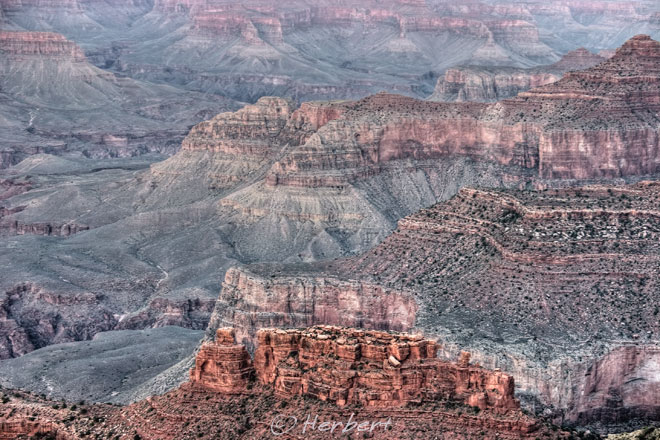 Location: Grand Canyon, USA (36.05335° N, 112.08344° W)
Date: 5 September 2006; 8.35am
Camera: Canon EOS 300D with Sigma 70-200/f2.8
The Grand Canyon must be one of the most recognisable canyon systems in the world. Though it is mo longer "the most" in many perspectives, it is still used as a yardstick for comparison purposes when other canyons are mentioned. For example, I often read that the Yarlung Tsangpo (deepest canyons in the world) is how many times deeper than the Grand Canyon and the longest canyon system, the Nujiang Gorge is how many times the total length of the Grand Canyon etc etc. I guess one of the reasons has to be the Western world is more familiar with the Grand Canyon and so using it as a comparison gives the readers both a sense of scale as well as a sense of identification.


July 28, 2009
Hot balloons in Yangshuo amongst the limestone karsts
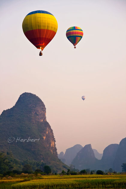
Location: Yangshuo, Guangxi, China (24° 47′ 0″ N, 110° 30′ 0″ E)
Date: 10 October 2008, 5.35pm
Camera: Canon 400D with Sigma 17-70/f2.8-4.5
Yangshuo is fast becoming a premier tourist hub with all the tourist amenities and activities that one can find anywhere. It was one of the earliest "real backpacker haven" with Western cafes, music in the early 1980's. It is now so touristy that one will have to struggle to find traces of authenticity anywhere in its vicinity. Hot ballooning is just another activity newly popular in Yangshuo. By the look of it, there is a real demand as I saw at least six balloons went into the air on that evening.
July 24, 2009
Lighthouse at the northern tip of NZ is a very windy place
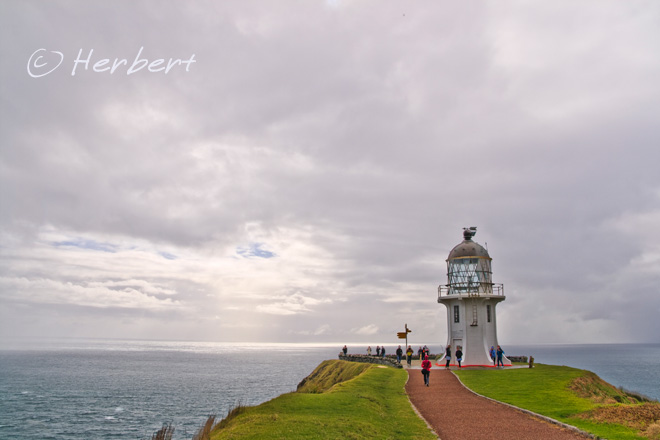
Location: Cape Reinga Lighthouse, New Zealand (34° 25′ 43.64″ S, 172° 40′ 51.61″ E)
Date: 10 May 2009, 10.30am
Camera: Canon 400D with Sigma 17-70/f2.8-4.5
Cape Reinga is a beautiful spot in the northern tip of New Zealand. It is commonly been mistaken (even by reputable guidebooks) as the northernmost tip of NZ- that honour actually belongs to Surville Cliffs which lies 30km to the east of here. Cape Reinga is often windy, being an exposed sliver of land protruding into the meeting of the Tasman Sea and Pacific Ocean. The cape is sacred to the Maoris as they believed that it is the point where the spirits of the dead enter the underworld. It is popular with tourists. One can drive to the cape easily (the nearest town, Kaitaia, is about 100 km south); however most tourists prefer to take a day tour as this normally include a drive on and along the fabulous 90-Mile Beach which is unsuitable for vehicles.
July 22, 2009
The changing face of Singapore especially the new CBD
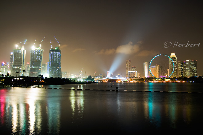
Location: View from Marina Barrage, Singapore (1° 16′ 50″ N, 103° 52′ 16″ E)
Date: 20 July 2009; 8.20pm
Camera: Canon 400D with Sigma 17-70/f2.8-4.5
The only certainty in Singapore is perhaps change. The skyline, retail facades and residential skyscrapers of the island is constantly changing. Many of the buildings, be it commercial or residential and retail facades that were around 10 years ago were either refurbished, renovated or plainly demolished to make room for newer, better and taller ones. The country is also in the midst of remaking its Central Business District (CBD) by relocating and building new office towers around the new Marina Downtown area. The picture at the Downtown area today (above) is distinctly different from two years ago. The Singapore Flyer in the photo (Ferris wheel) was only operational in early 2008. The so-called Integrated Resort named Marina Bay Sands Resort, which is in effect a huge casino complex represented by the three towers at the left of the picture, is scheduled for completion by year-end. A couple of other projects are in the pipeline to maintain the change momentum.
July 19, 2009
Mount Tawache & Cholatse among the giants of the Himalayas
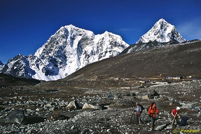 Location: Lobuche, Khumbu, Nepal (27° 57′ 34.2″ N, 86° 47′ 23.8″ E)
Date: 16 May 2000; 7.15am
Camera: Canon EOS 500N(analogue) on slides and scanned
Some parts of the Khumbu valley are like moonscape especially closer towards Everest. Glaciers had scarred the landscape for centuries and rocks, boulders and moraine are scattered over wide areas. In between, giant snowy mountains peek out of the landscape such as Tawache (6,501m) and Cholatse (6,440m) which towers over the village of Lobuche in the above photo. However, the landscape of the region had changed tremendously in the last few years as a result of global warming. Recently I saw some photos of the Khumbu area and was shocked at how bare it had become- the glaciers had retreated and the landscape is brown, no longer covered by snow/ice.
July 16, 2009
Coracle among boulders of Hampi, India
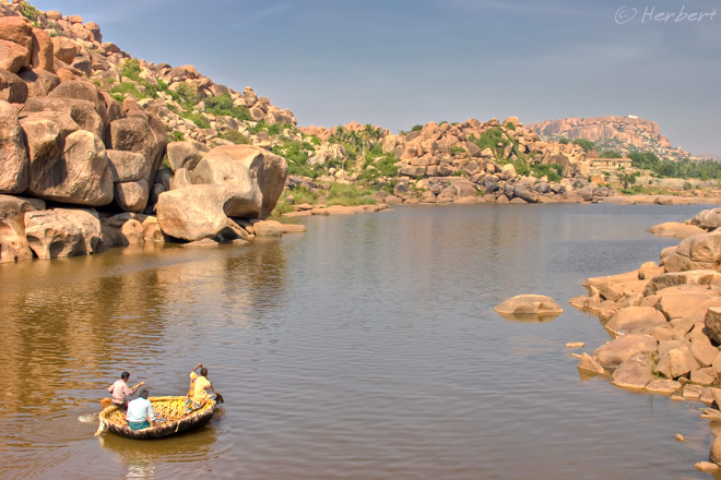 Location: Hampi, Karnataka, India (15° 20′ 9″ N, 76° 27′ 39″ E)
Date: 27 November 2005; 2.45pm
Camera: Canon 300D with kit lens
One of the fun things to do at Hampi in Karnataka (see this post for introduction of Hampi) is roaming around the rock boulders along the Tungabhadra River to search for carvings of Hindu gods on the rocks. There are many such carvings as well as little shrines all over the place. However, the shrine with the best location as well as most prominent is the Monkey Temple on Anjenaya Hill (the white patch at the top of the hump in the distance in the above photo). To get there, one have to cross the river by taking a ride on a "Dongi" or round-shape bamboo coracle and then climb 572 steps to the temple. The temple itself is just a small chamber, devoted to Hanuman, the Monkey God. It is a popular place for sunrise and sunset.
July 14, 2009
Sunrise at Bromo-Tengger-Semeru National Park, Java, Indonesia
 Location: Bromo-Tengger-Semeru National Park , East Java, Indonesia (7°59'7.19"S 112°59'9.64"E)
Date: 16 July 2008; 8.10am
Camera: Canon 400D with Sigma 17-70/f2.8-4.5
Bromo-Tengger-Semeru National Park in East Java is my favourite destination in Indonesia. It is quite a touristy place, popular amongst Indonesians and foreigners alike. However apart from the morning crunch during sunrise at the viewing platforms at Gunung Penanjakan and later on at Gunung Bromo itself, one will not really feel the crowd for the rest of the day. This could be because many of the tourists are only day-tripping for the morning sunrise and walk up to the caldera of Gunung Bromo. Furthermore, there are a few access points and so, accommodation options, rather than all cramped into Cemoro Lawang, which is the closest village. I also suspect that many of the tourists will simply stay at their rooms to recuperate during the day. There are many other choice locations to enjoy the volcano panoramic in the morning (and evening) apart from the one that all jeeps go with their guests. These other ones may not be as high but there are at more interesting angles; but some bush thrashing may be necessary. The above photo as well as this misty shot are taken from these alternative spots.
July 11, 2009
Narrow cave opening connecting a hong to the sea, Thailand
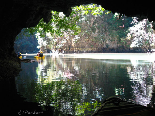 Location: Phang Nga Bay, Thailand (8° 17′ 0″ N, 98° 36′ 0″ E)
Date: 6 March 2009; 11.25am
Camera: Canon IXUS IZoom
As introduced in this post, Phang Nga Bay is full of little isolated islands with collapsed cave systems and hongs- tidal sink holes in the middle of the islands- opening to the sky. These hongs are connected to the sea by narrow caves., some so narrow that paddlers have to lay on their backs to get through. As the opening gets closer, one's vision switched from that of darkness to greens reflected on tranquil waters like this photo.
July 9, 2009
A snowy morning at Karakul Lake, Xinjiang, China
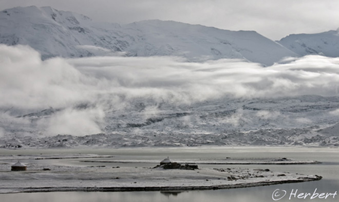 Location: Karakul Lake, Xinjiang, China (38° 26′ 0″ N, 75° 3′ 0″ E)
Date: 10 June 2004; 8.15am
Camera: Canon 300D with kit lens
Karakul Lake is approximately 200 km on the road towards Khunjerab Pass, the border crossing between China and Pakistan. It is a beautiful high alpine lake at about 3,600m and is surrounded by snow-peak mountains (also see this post). There are a couple of Kirgiz settlements along its banks. However, around 2003, a small cluster of yurt-tents and a couple of Chinese restaurants sprang up. A gaudy gantry was also erected near the same spot, at the entrance of a small paved road leading from the main road to the lakeshore. These people who run the restaurant and rent out the yurt-tents (think a couple of Chinese families) started collecting entrance fee of 50 RMB per person to visit the lake. Honestly, I am not sure if these people are actually authorised to collect any entrance fee (like many parts of China) but they will not allow one to go pass without paying. When I attempted to go back to Karakul Lake at the end of 2008 (after the Tibetan disturbances), I was told that I need to get a special permit to visit the lake. I guess the Chinese government was sensitive with foreigners in remote places of China after the Lhasa disturbances. Unfortunately, they did not trust their instincts enough and so did not start enacting policies or taking steps to reduce the marginalization of the Uighers that lead to the deadly riots in Urumqi on 4 July.
July 7, 2009
Colourful laundry marts, Dhobi Ghats of Mumbai, India
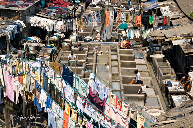
Location: Dhobi Ghat at Saat Rasta, Mumbai, India (18° 59′ 0″ N, 72° 48′ 0″ E)
Date: 11 April 2008; 1.30pm
Camera: Canon 400D with Sigma 17-70/f2.8-4.5
Dhobi- laundry- is common everywhere in India. Traditionally the laundry was washed close to a river, lake or reservoir and then spread on the banks or hang on lines to dry in the sun. This is still a common sight in many parts of India. In major cities, it is more common for the laundry to be done in "ghats” open-air concrete wash pans with flogging stones. The most famous of these Dhobi Ghats and perhaps the largest outdoor laundry is at Saat Rasta near Mahalaxmi Station in Mumbai, where around two hundred dhobis and their families work together in what has always been a hereditary occupation. The dirty garments are washed in soapy water- stubborn stains are removed by soaking them in boiling vats of caustic soda- thrashed on the flogging stones and then hung out to dry. They are pressed the next day using heavy wood-burning irons and piled into neat bundles to be returned to their owners. I am always amazed at how they can remember which garments belong to whom.
P.S. Even modern Singapore also has such ghats during the colonial times. The laundry was washed in a stream that used to be known as Sungei Bras Basah that flowed from Orchard Road to the sea (it is now the Stamford Canal). The laundry were then dried in the open space between Bras Basah Road and Stamford Road- which is why that area and the MRT station today is known as Dhoby Ghaut.
July 5, 2009
Half Dome simmering in sunset rays
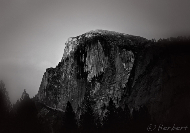 Location: Yosemite National Park, California, USA (37°43′18″N 119°38′47″W)
Date: 14 September 2006; 7.15pm
Camera: Canon Canon 300D with kit lens
I have to admit that I was slightly disappointed with Yosemite. I have read and seen many photos of the Park but when I was there, I was not exactly impressed by what I saw. I am a bit of a "mountain person" and so was expecting to see some relatively impressive mountain sceneries. The Half Dome and El Kapitan are not quite as majestic as the mountains I used to see in Asia. I guessed I was not used to the fact that a National Park such as Yosemite is so crowded, like an urban park.
July 2, 2009
1-way bridges common in New Zealand
 Location: Richardson Range, Kinloch, Otago, New Zealand (44° 51' 0" S, 168° 20' 0" E)
Date: 22 May 2009, 11.30am
Camera: Canon 400D with Sigma 17-70/f2.8-4.5
Kinloch is a very small settlement situated at one end of Lake Wakatipu in the South Island of New Zealand. It is directly at the opposite bank of the lake to another small town, Glenorchy. Glenorchy had quite a high profile in the last few years as the site of no less than four Lord of The Rings film shooting locations. Many of the outdoor locations of the movie "X-Men Wolverine" were also shot around here. One can quickly understand the popularity of this area for such locations after spending a couple of hours driving or walking the vicinity. The scenery is one of sheer stark beauty with snowy peaks of both the Richardson and Humboldt Ranges framing the west and east shores of the lake, fed by both the Dart and Rees River. However, drivers have to be always on the alert for this road sign- 1-way bridges, give way- that are common in the South Island.
Subscribe to:
Posts (Atom)