

December 31, 2010
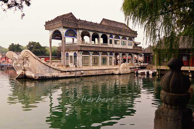
A Marble Boat that is not really marble
Location: Marble Boat, YiheYuan, Beijing, China(39° 59′ 48.4″ N, 116° 15′ 48.9″ E)
Date: 19 October 2010, 11.10am
Camera: Canon 500D with Sigma 17-70/f2.8-4.5
Yuheyan, the Summer Palace was the summer retreat of the Chinese Emperors/Empress. The Palace is actually a landscape garden with a variety of pavilions, gardens, palaces etc centred around Kunming Lake and Longevity Island. The man-made lake was an imitation of Xihu of Hangzhou and the soil excavated from the lake was used to make Longevity Hill. The Summer Palace was destroyed twice —during the Anglo-French allied invasion of the 1860 2nd Opium War and during the attack by the eight allied powers in the 1900 Boxer Rebellion. The Old Summer Palace (YuanMingYuan) was also destroyed in the 2nd Opium War and was burnt down with looting and plundering of Chinese arts and treasures by British and French soldiers. Whilst the YiheYuan was rebuilt after the 1st destruction, YuanMinYuan was left as it is. Ironically the rebuilding of YiHeYuan by diverting funds originally designated for the Chinese Navy contributed to her second destruction. The destructions of these compounds etched a deep wound in the Chinese psyche as they represent the apex of Chinese humiliation and bullying in the hands of Western powers. These events continue to shape the mind and thinking behind some of China’s foreign and defence policies today.
One of the iconic structure in YiHeYuan is the so-called Marble Boat, a lakeside pavilion on the grounds of the Palace. It is a 2 storey structure which is not actually marble. It has a large stone base with wooden superstructure painted to imitate marble.


December 28, 2010
The “Mosque of the 4 Minarets” of Hyderabad (also known as Cyberabad or Tollywood)
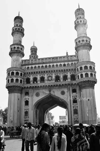
Location: Charminar, Hyderabad, Andhra Pradesh, India (17° 21′ 41″ N, 78° 28′ 28″ E)
Date: 27 November 2005; 2.45pm
Camera: Canon 400D with Sigma 17-70/f2.8-4.5
Hyderabad is the 6th largest city in India. It has developed by leaps-and-bounds in the last few years especially as a major hub in the IT industry, earning itself the nickname “Cyberabad”. It is also the home of the Telugu Film Industry, second biggest only to Bollywood in India; that’s why the city is sometimes referred to as Tollywood. It has a huge Muslim minority and one of the most famous monument of the city is the Charminar literally meaning the Four Minarets. Charminar was built by a Sultan in 1591 after fulfillment of a prayer for the end of a plague that was ravaging the city. The monument is in fact a mosque (on the top floor of the structure) within a fort, made of granite, lime, mortar and pulverised marble. Surrounding the monument is the most bustling bazaar of Hyderabad, the Laad Bazaar. Due to the big Muslim population of the city, Hyderabad has reputedly the best Nasi Biryani (a Muslim rice dish) one can ever find in India.
December 26, 2010
The beautiful Art-Deco building, T & G Building in centre Napier
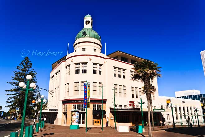
Location: Napier, New Zealand (39° 29′ 0″ S, 176° 55′ 0″ E)
Date: 16 May 2009, 9.40am
Camera: Canon 400D with Sigma 17-70/f2.8-4.5
Napier is one of the so-called “Twin Cities’ on the eastern coast, Hawkes bay, of New Zealand; the other of the twin is Hastings. It is a major port for the region, shipping most of the North Island’s wool, citrus fruits and pulp and timber. The city is more well-known for its Art-Deco buildings. Napier was leveled by an earthquake in 1931 and was rebuilt in the style of the then-popular Art-Deco style. Though many of the buildings had been replaced by more modern designs, most of the Art-Deco buildings in the city center remained intact. Today these are the major tourist attractions though a statue akin to the Mermaid of Copenhagen, known as the Pania of the Reef, is much photographed. Honestly you don’t miss anything if you have not seen the statue.
December 25, 2010
December 22, 2010
One of the most published images of Bangkok- Wat Arun
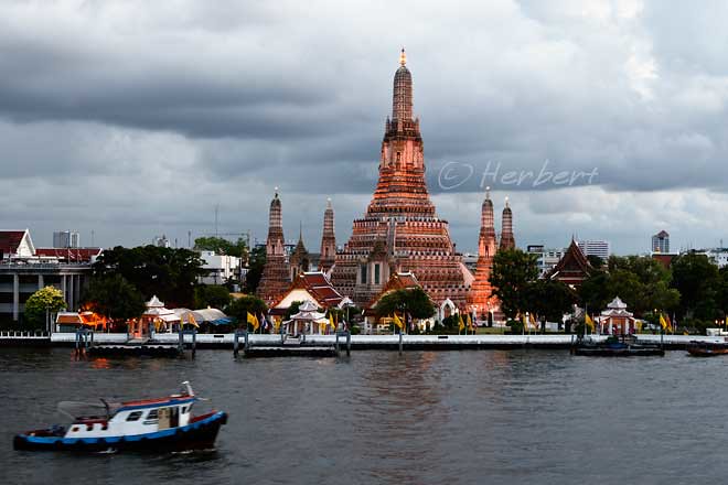
Location: Wat Arun, Bangkok, Thailand (13° 44′ 38″ N, 100° 29′ 19″ E)
Date: 24 June 2010, 6.35pm
Camera: Canon 400D with Canon 70-200/f4.0
Wat Arun is one of the best known landmarks of Bangkok. Situated on the west bank of the Chao Phraya River, it consists of a massive elongated prang (Khmer-style tower), and is surrounded by four smaller prangs. The prangs are decorated by seashells and bits of porcelain which had previously been used as ballast by boats coming to Bangkok from China. It is quite an interesting temple to visit but more stunning to look at from the opposite bank especially during sunset.
December 19, 2010
China is a place to go pick up handicrafts, traditional and modern ones alike
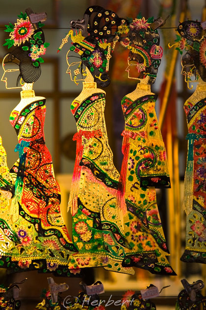
Location: Wuhouci, Chengdu, China (30° 39′ 35″ N, 104° 3′ 48″ E)
Date: 10 October 2008; 2.50pm
Camera: Canon 400D with Canon 70-200 f/4 L IS Lens
One of my favourite activities while travelling in China used to be shopping for handicrafts and collectibles. I enjoyed collecting unique handicrafts- those only produced in very small quantities and perhaps one-of-its-kind and not-too-perfect pieces rather than the factory mass-produced pieces. In the early days when China started opening its doors to outsiders, one can pick up many valuable collectibles at very good prices. For instance, I remembered buying a fabulous wood carvings from bed rests during my first trip in 1996 that used to have a vaunted place on my display shelf. However these days, anything closely resembles uniqueness are very expensive in China. That’s why I do not spend time looking for them anymore- only occasionally browsing just to see what’s in the market. Furthermore I do not have a big enough place to even showcase my current collection- adding more is just going to go to the storage.
December 16, 2010
Amazing hand-blown “flowers” of Bellagio- a must-see of Vegas
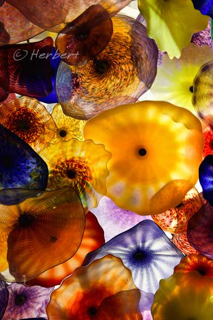
Location: Lobby ceiling of Bellagio Hotel, Las Vegas, Nevada, USA (36° 6′ 47″ N, 115° 10′ 35″ W)
Date: 8 September 2006; 4.15pm
Camera: Canon 300D with kit lens
Las Vegas is really a fun place to go especially for gamblers. Even for non-gamblers like me, it is just fun to hop from hotel to hotel to see the free performances and enjoy the “freak show” so to speak. Amongst other things ,one could see Eiffel Tower and the Pyramid here as well as the most glittering of lights. All the hotels on the Strip of Vegas seem to try to outdo one another all the time, with different themes and attractions. One of the highlights for any Vegas visitors must be the Bellagio Hotel. It has an 8-acre (3.2 ha) man-made lake outside the building which houses the Fountains of Bellagio, a huge dancing fountain with performances synchronized to music and light. Its lobby’ s ceiling is adorned by the “Fiori Di Como” chandelier which comprises of 2,000 hand-blown multi-colored glass blossoms.
December 13, 2010
Srinagar, Kashmir at better times, just a year ago
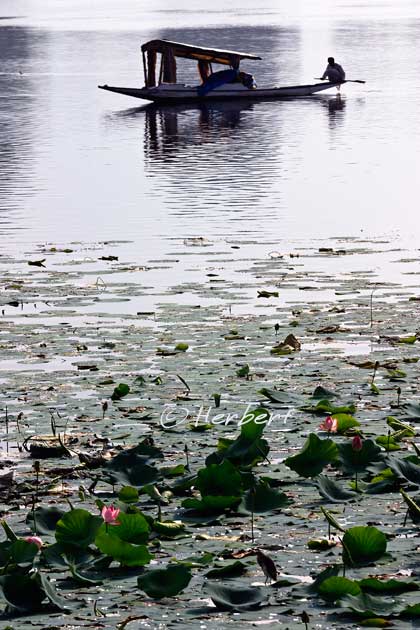
Location: Dal Lake, Srinagar, Kashmir, India (34° 5′ 24″ N, 74° 47′ 24″ E)
Date: 15 August 2009 8.30am
Camera: Canon 400D with Sigma 17-70/f2.8-4.5
This was Dal lake of Srinagar a year ago. Just how much things have changed for the Kashmir Valley in just one year. Protests on the streets of Srinagar in the middle of this year descended into killings of activists and protesters by the Indian Army and Police. The death toll was at least 60, mostly rock-hurling civilians shot dead by police. Whilst the Kashmiri issues are complex and intractable, it is still rather hypocritical of the so-called Western democracies for not raising much of a ruckus to India over the killings. The same cannot be said if the country was Iran or China. Civilian lives often became pieces of pawn on a chessboard to be sacrificed for the greater gains. I was blessed to have the opportunity to visit this beautiful place during one of its most peaceful period and I hope that peace and common sense will again prevail in the Valley very soon.
December 10, 2010
A truly unique Sri Lankan tradition…. stilt fishing
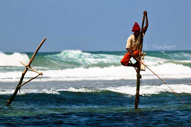
Location: Ahangama, Sri Lanka (5° 58' 40 N, 80° 22' 28 E)
Date: 12 October 2010, 6.10pm
Camera: Canon 500D with Sigma 17-70/f2.8-4.5
One of the most iconic images of Sri Lanka is that of men fishing while perched precariously on poles in the middle of rushing waves.The fishermen sit on a cross bar called a petta tied to a vertical pole planted into the coral reef. They hold the stilt with one hand while fishing with a rod using the other. The poles are about 3-4 m long with about half a meter driven into the reef; so the fishermen is about 2 m above water at high tides. The fishes they catch are small herrings, sardines and mackerels that hang around the shallow reefs. Any fishes caught are stored in a plastic bag tied around their waist or the pole. This is stilt or pole fishing, a tradition that is uniquely Sri Lankan; but a dying tradition with dwindling practitioners. Most stilt fishermen are found on the south and eastern coast of the island. However these days near the tourist resorts along the south coast, there are more so-called stilt fishermen who will pose for a fee for tourists to snap their photos.
December 7, 2010
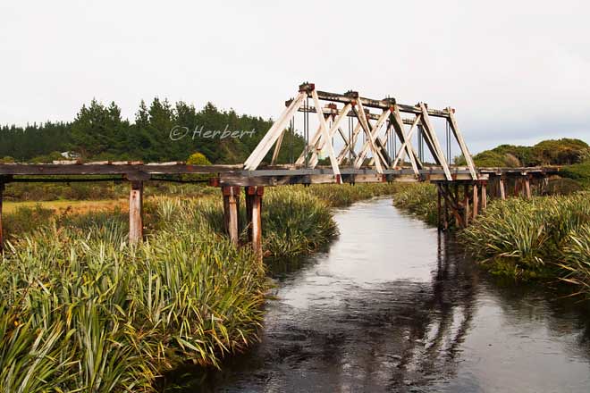
This should be left standing………………….
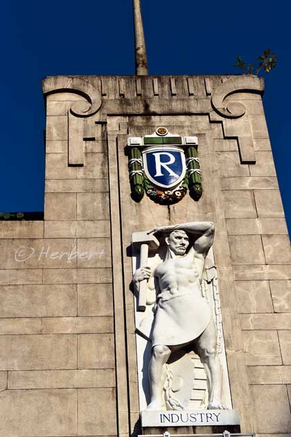
Location: Tanjong Pagar KTM Railway Station, Singapore (1° 16′ 22″ N, 103° 50′ 17″ E)
Date: 3 August 2010, 8.35am
Camera: Canon 400D with Sigma 17-70/f2.8-4.5
The Tanjong Pagar Railway Station located in Singapore is the terminus station of the Malaysia Railways (Keretapi Tanah Melayu). The land on which the station and the railway tracks in Singapore are situated is held by KTM on a 999 year lease. The station entrance has statues of white marble, allegories of Agriculture, Industry, Commerce and Transport. Inside the station, there are panel paintings of Malayan scenes: rice planting, rubber tapping, shipping activities, tin mining and so on. Singapore was part of Malaysia until they separated in 1965; when the border control was established after separation, both the Malaysian and Singaporean Customs, Immigration and Quarantine (CIQ) officers were stationed at Tanjong Pagar for immigration clearance of railway passengers even though the station is in fact deep at the other end of Singapore. In 1998 Singapore moved its CIQ functions for railways to Woodlands, which is at the point of entry into Singapore but Malaysia continues to maintain its CIQ functions at Tanjung Pagar. This created a situation whereby rail travellers leaving Singapore actually got checked into Malaysia (technically the station and the railway tracks are Malaysian territories) before they are cleared out from Singapore at Woodlands. This confused state has persisted for the last few years; as a result of a recent agreement between the governments, Malaysia will move its CQ to Woodlands as well by 1 July 2011. The Singapore Government has not being decided as to what will happen to the magnificent Railway Station after the relocation; I personally hope that the station architecture and sculptures will be kept intact.
November 30, 2010
November 22, 2010
Golden temple- it is really gold!!
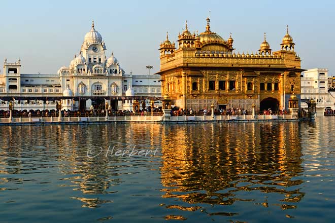
Location: Golden Temple at Amritsar, India (31° 36' 0 N, 74° 52' 0 E)
Date: 24 June 2007: 6.30pm
Camera: Canon 400D with Sigma 17-70mm/f2.8-4.5
The Sikh Golden Temple of Amritsar is definitely one of the highlights of anyone’s visit to India. Though it is not as well-known or popular as some other Indian destinations such as Taj Mahal, Red Fort etc, it is to me, one of the most memorable destinations of India. As was discussed in a previous post on this temple, this place exudes a certain sense of peacefulness and tranquility like no other places in India. If the UNESCO Heritage Site includes existing places of worship, the Golden Temple will definitely get my vote as a candidate.
November 18, 2010
China is rebuilding Tibet’s transport infrastructure at a frantic pace
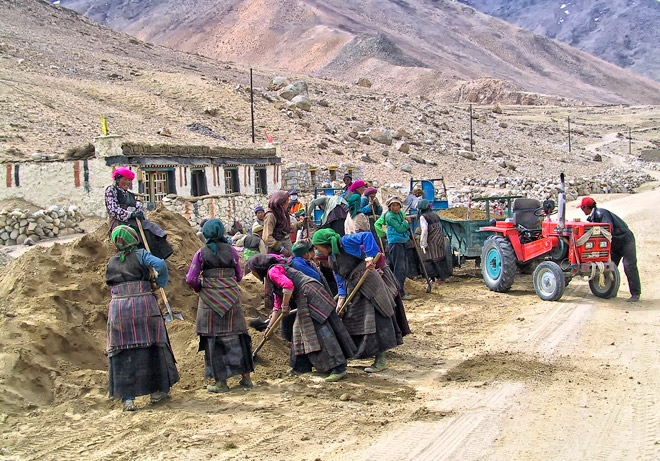
Location : Tingri region, Tibet, China (28° 34′ 0″ N, 86° 38′ 0″ E)
Date : 28 April 2003; 8.25am
Camera : Canon G1
Tibet is developing so fast that it is quite mind boggling. Billions are poured into the province’s transport infrastructure with the headlining rail connection to Lhasa. Apart from that, China is building the world’s highest airport at Ngari (base to explore Mount Kailash), airport in and extension of the Lhasa rail line to Shiigatse. It is also expanding and improving the road network in the province. Few years ago the road between Lhasa and Shiigatse was a single lane bitumen road; now it is a 4-lane highway! However most of the roads in Tibet are under-utilized. It is not unusual to be on one of these roads for 20 or so minutes before encountering another vehicle. Most of the constructions connecting the major centers are undertaken with heavy machineries but some of the lesser connections are invariably still mainly built by manual labour, with little heavy machinery. This photo was the norm as far as road construction is concerned about 8 years ago- men and womenfolks using shovels- and is still the same in the smaller town connections.
November 14, 2010
The carvings of Borobudur are in danger of being damaged by the volcanic ashes of Mount Merapi
Location: Borobudur, East Java, Indonesia (7°36′29″S 110°12′14″E)
Date: 21 July 2008; 9.40am
Camera: Canon 400D with EF 70-200/f4 IS L
Borobudur is under siege again, this time from nature. The continuing eruptions of Mount Merapi with its consequent release of huge amount of volcanic ash into the air are causing great concerns to the experts on the preservation of Borobudur. Apparently the statues and stupas of the monument are already coated by volcanic ashes 5 cm thick. The volcanic ashes are acidic and could cause irreparable damage to the monument as it embeds into the pores of the structures. Army of staff had been deployed to clean up the ashes and the authorities planned to cover the monument with a huge piece of plastic to prevent the ashes from contaminating the monument. However due to the size of the monument, the huge plastic sheet is only big enough to be used to cover the more important structures. Let’s wish them success.
November 9, 2010
Mount Merapi at sun rise, before the current round of eruptions
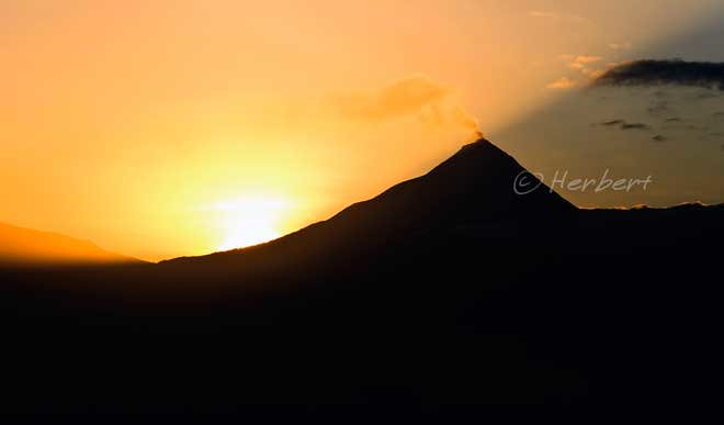
Location: Borobudur, East Java, Indonesia (7°36′29″S 110°12′14″E)
Date: 21 July 2008; 6.10am
Camera: Canon 400D with Sigma 17-70/f2.8-4.5
Mount Merapi is one of the most active volcanoes in Indonesia. It has just blown its top for the last 2 weeks and had claimed at least 150 lives. It is a beautiful volcano to look at when it is inactive especially as a backdrop to the fabulous Borobudur complex. This is diametrically different to what it looks like in the last few days with reports of ashes being thrown up 8 km into the sky. In fact the volcanic ashes even fell on Borobudur, 28 km away causing experts to fear that the acidic ash might damage the historic site. Though it is dangerous to live close to the volcano, the fertility of its soil resulting from the volcanic ashes, had attracted a huge population of farmers on its slope. I would venture to guess that after the ashes had settled, farmers will flock back to till on its slopes.
November 6, 2010
The ever popular Erawan shrine of Bangkok, Thailand
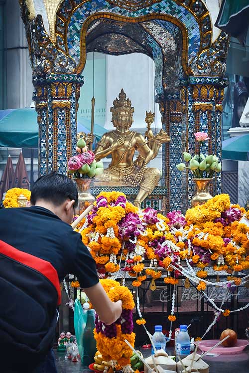
Location: Erawan Shrine, Bangkok, Thailand (13° 44′ 49″ N, 100° 32′ 23″ E)
Date: 28 October 2009, 11.05am
Camera: Canon 400D with Sigma 17-70/f2.8-4.5
The Erawan Shrine or San Phra Phrom is located diagonally opposite to Central World Shopping Mall in central Bangkok (part of the Central World Shopping Mall was burned down in the recent Red Shirt riots on 19 May 2010). The shrine is a well-known landmark in Bangkok, familiar to Thais and foreigners as thousands of devotees both Thai and foreigners pray at the shrine to seek blessings, fulfillment of dreams, success in personal lives and careers every day. The shrine was actually constructed to honor the 4-faced Hindu god, Brahma. However the shrine is popularly known to foreign visitors as the 4-face Buddha; which is incorrect as it is a not a Buddha. The shrine got its name, Erawan, from Brahma’s 3-headed elephant.
The gold plated plaster Brahma statue was smashed and destroyed on 21 March 2006 by a mentally ill man- he was beaten to death on the spot by two workers. The statue was replaced by metal one made of an alloy, nawaloha, consisting of nine metals including gold and silver. It remains as popular prayer shrine as its predecessor.
November 1, 2010
China’s old folks are really healthy!!!
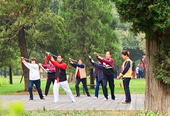
Location: Tian Tan, Beijing, China(39° 52′ 56.07″ N, 116° 24′ 23.29″ E)
Date: 18 October 2010, 9.10am
Camera: Canon 500D with Sigma 17-70/f2.8-4.5
I am always amazed by how healthy the elderlies of China are. Whether in the rural farming areas or in the cities, the majority of the elder folks in China are generally very healthy and mobile. I supposed the cause of this in the rural areas is the laborious nature of their life in the farms while in the cities, the reason is their devotion to exercises of all sorts. In fact in the cities, one can always see the residents exercising in the parks in the mornings and evenings. A popular exercise is of course, taiji; but it is by no means limited to that. Some of the more popular exercises/sports are dancing, badminton and the various forms of light martial arts.
October 30, 2010
A living Dutch-style walled city in Sri Lanka

Location: Fort Galle , Galle, Sri Lanka (6° 1′ 53.19″ N, 80° 12′ 58.78″ E)
Date: 12 October 2010, 6.10pm
Camera: Canon 500D with Sigma 17-70/f2.8-4.5
I first visited Galle in 1996 and spent less than 2 hours there. I did not do much research about the place then and went there because it is one of the tourist destinations touted by travel publications on Sri Lanka. I was a little disappointed with Galle then as there was really nothing to see apart from some old style Dutch buildings which are in various state of disrepair. Later I realised that it is a UNESCO Heritage Site. Lately I have read some travel guides that described the place with flowing praise, more for the so-called transformation into a shopping paradise for arts and the money spent, mainly by rich European expatriates in renovating and transforming some of the older buildings into boutique hotels and art outlets. So I told myself I must spend two days there the next time I visit- which I did recently- I specially extended my stay in Sri Lanka for this. Well, I was reasonably disappointed again. Yes, there had been some restoration of old buildings but the audience is obviously rich Europeans tourists. Most of the houses and churches are still in “original” state despite the “city” being a UNESCO site and hence, getting funds to preserve and upkeep. I guess the UNESCO inscription was for a “fortified city built by Europeans in South and South-East Asia, showing the interaction between European architectural styles and South Asian traditions.” and in that sense it is correct. I do enjoy the fact that it is a living city with people actually living and breathing in the old houses, and for centuries for that matter. But that is also changing- many of the houses are already under renovation and soon the character of this place will change from being a living city to a commercial city.
October 28, 2010
The “Crown of Jaipur” Hawa Mahal, Rajasthan, India
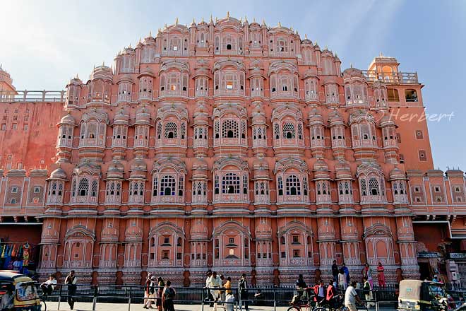
Location: Hawa Mahal, Jaipur, Rajasthan, India (26° 55′ 26″ N, 75° 49′ 36″ E)
Date: 3 Jan 2009; 8.30am
Camera: Canon 400D with Sigma 17-70/f2.8-4.5
Jaipur forms one of the legs of the so-called “Golden Triangle” of Delhi-Agra-Jaipur that nearly every tourist to India will visit. The city is a chaotic city- just like anywhere in India- and has a few interesting attractions, including the UNESCO Heritage Site of Jantar Mantar. However I always enjoy visiting the Hawa Mahal in the city.
Hawa Mahal means the “Palace of Winds” and is part of the City Palace complex. Nothing much of it is left except its exterior five-storey structure. The structure was designed like the crown of the Hindu god, Krishna. but with 953 small windows known as jharokhas, decorated with intricate lattice work. the windows was designed to allow royal ladies to observe everyday life in the street below without being seen as they have a tradition of strict face covering (purdah) for the ladies then. Hawa Mahal was for many years in a rather derelict state with peeling paint and broken windows until a restoration effort that started in 2005. It is now somewhat more “pretty”.
October 26, 2010
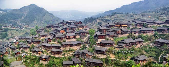
Ancient roofs of a remote Dong village, Guizhou, China
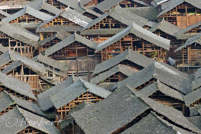
Locations: Zhencong, Guizhou, China( 25°54'30.67"N 109°11'43.82"E)
Date: 17 April 2005; 8.15am
Camera: Canon 300D with kit lens
Guizhou is a treasure trove for travelers who enjoy experiencing ethnic diversity. Even though the province does not have as many different ethnic groups as Yunnan, it is less developed due the landscape- hilly and not-as-good transport links. Therefore the ethnic minorities in this province are more “genuine” in their practices and lifestyle; whereas in many parts of Yunnan, many of the ethnic practices are staged for tourists. The ethnic minority in this province is dominated by three large groups- the Zhuang, Dong and Miao. The Dong are most well-known for their Drum Towers and majestic Wind and Rain Bridges while the Miaos are known for their festivals, diversity and their signature stilt dwellings. Many of these villages are now popular tourist destinations though there are still some gems that are well-hidden- too difficult and convoluted to visit. One example is the Dong village of Zhengcong which is a small village surrounded like an island by a stream with beautiful surroundings and houses. The villagers still practice their own custom and go around their business in their traditional costumes. It is one of those places where you will not find a guesthouse or anything close to it.
October 23, 2010
Inside a Greek Orthodox Church, Samos, Greece

Location: Samos Island, Greece (37° 44′ 0″ N, 26° 50′ 0″ E)
Date: 3 April 2010; 3.35pm
Camera: Canon 400D with Canon 70-200/f4L USM
Greece practice a different type of Christianity- Greek Orthodox. Greek Orthodox churches can be seen all over the country. As I am no expert on Christianity, I cannot really tell the difference with Catholic or Protestant churches. However Greek churches seem to be more “conservative” in decoration and we have been advised not to take photos in many of the churches we stepped in to have a look.
October 20, 2010
Giant calligraphic medallions inside Hagia Sohpia, Istanbul, Turkey
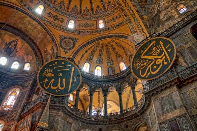
Location: Inside of Hagia Sophia, Instanbul, Turkey (41° 0′ 31″ N, 28° 58′ 48″ E)
Date: 20 April 2010, 9.40am
Camera: Canon 400D with Canon 70-200/f4L USM
Hagia Sophia is a former church, then a mosque, and now a museum. It was the largest cathedral in the world for more than a thousand years. The cathedral was converted into a mosque after the Ottoman Turks conquered Constantinople (Istanbul’s former name) from the Byzantine Empire. It is one of the grandest current and former religious buildings that I have the pleasure of visiting. To me, this building is comparable to the Vatican’s St Peter’s Basilica in its grandeur and place in history. There are many interesting historical and architectural aspects to the building, all enmeshed with the Byzantine and Ottoman Empires’ history. On entering the museum, one of the most distinguishing sights is the 8 gigantic circular-framed disks or medallions hanging on the columns. These were inscribed with the names of Allah, the Prophet Muhammad, the first four caliphs and the two grandchildren of Mohammed. Hagia Sophia is a MUST-SEE stop on anyone’s visit to Turkey.
October 18, 2010
Old Bridge in Bruce bay, South Island, New Zealand
Location: Bruce bay, South Island, New Zealand (43° 36′ 0″ S, 169° 34′ 0″ E)
Date: 12 May 2009, 2.15pm
Camera: Canon 400D with Sigma 17-70/f2.8-4.5
Bruce bay is a windswept bay in the West Coast of the South Island. Here one can enjoy a sweeping coastal view of the Tasman Sea thrashing against the coast line. The coast is lined by elegant Rimu trees while the beach is largely deserted except for stones and driftwood. However it is rather spectacular in its sparseness and wild grandeur. The settlement here is old and was established mainly as a result of a Gold Rush in the 1860’s. Hence one can still see some old structures and elegant bridges still standing.
October 16, 2010
The gracious Siguniang Shan of Sichuan, China
Location: Siguniang Shan, Sichuan, China (30°59'59.57"N 102°51'4.85"E)
Date: 29 October 2006, 4.40pm
Camera: Canon 300D with kit lens
Siguniang Shan means the “4 Sisters Mountains”. It is located in the Aba Tibetan Autonomous Prefecture in Sichuan, the same prefecture of the famed Jiuzhaighou Scenic Reserve. Siguniang is a Nature Reserve as well and is managed by the same company that has managed Jiuzhaighou. Hence the protocol of visiting this place is similar to Jiuzhaighou- one pays for entrance fee and a fee for the hop-on-hop-off bus service within the Reserve. There are three valleys within the reserve and there is an entrance fee (separately) for each valley.
Siguniang is well-known for its snow peaks, valleys, forests, lakes and biology. It is a UNESCO Heritage Site together with the Wolong and Jiajin Mountains forming the Sichuan Giant Panda Sanctuaries. According to the legend of the local Tibetan people, millennia ago there was a mountain god named Balang who had four beautiful daughters. The youngest of them was the tallest and had the most graceful figure. A devil admired the girls and wanted to marry them. So the devil challenged Balang to a fight for the girls. The devil won the battle and killed Balang, so the girls fled but eventually died from cold weather. Their bodies became the Siguniang Mountains and their father became the Balang Mountain. The Siguniang Mountains stand graceful, shoulder by shoulder plunging their heads into the clouds, with glaciers wrapping around their shoulders and green forests around their waists. The youngest girl is the tallest at 6,250m above sea level.
October 14, 2010
Youngster practicing cricket batting in Galle, Sri Lanka
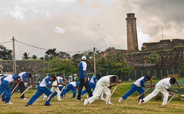
Location: Galle International Stadium, Galle, Sri Lanka (6° 1′ 53.19″ N, 80° 12′ 58.78″ E)
Date: 11 October 2010, 4.40pm
Camera: Canon 400D with Sigma 17-70/f2.8-4.5
Cricket is the most popular game in South Asia and in many other former British colonies, the most popular summer game. It is played as 5 days Tests and One Day Internationals. Test cricket is a strategic game but One Day cricket really brings the game to the mainstream, adding a higher level of excitement by capturing the audience attention with the shorter game perfectly suited to the TV era.
Sri Lanka is a relatively new player in the international cricket scene, having only obtained Test status in 1981. However it has managed to capture the imagination of the cricket world by winning the Cricket World Cup in 1996 and the International Cricket Council Champions trophy in 2002 as well as being the runner up in a few other international championships. Sri Lanka has within its ranks greats such as Muttiah Muralitharan (often referred to as simply Murali), the highest wicket taker in both Test cricket and 1 Day internationals. Most of the great cricket players of Sri Lanka and other countries such as Pakistan are in fact “hailed from the streets”. However these days cricket is such a big game that youngsters go through structured training programs to hone their batting and bowling skills. It has also become such a big money game that it is rife with corruption as big bets are placed on many small specific aspects of a game. Many talented Pakistani players are notoriously associated with cricket corruption.
October 12, 2010
Still Travelling
I am still tarvelling and will be back within a couple of days. More posts & photos will follow.
October 4, 2010
South Gate Angkor Thorn- depiction of a Hindu myth
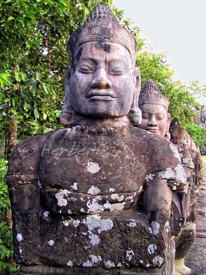
Location: Devas at South Gate, Angkor Thorn, Siem Reap, Cambodia (13° 26′ 35.89″ N, 103° 51′ 34.85″ E)
Date: 13 November 2002; 11.40am
Camera: Canon G1
Angkor Thorn is within the Angkor Wat complex of Siem Reap, so to speak. It is however, not actually part of Angkor Wat- it is in fact the last capital of the Khmer kingdom. Visitors to Angkor Wat will probably not bother to make such a distinction; it is after all part of a visit to Angkor Wat. There are several distinguishing features of Angkor Thorn but the row of statutes lining the length of the entrance to the South Gate is one of the more enduring. On the left are the gods while on the right are the demons, or asuras. They are supposed to be engaged in a tug-of-war holding on to the seven-headed serpent, or naga. This is a depiction of the Hindu creation myth, Churning of the Ocean of Milk, which is also shown on the bas-relief of Angkor Wat.
September 27, 2010
Greens and sand dunes- this is Mingsha, Gansu
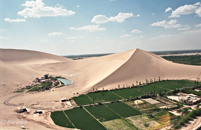
Locations: Mingsha, Gansu, China (40°5'18"N 94°40'33"E )
Date: 5 October 2008; 9.20pm
Camera: (analogue) Canon 500N with negatives and scanned
Dunhuang is one of the most interesting stops along the Silk Route of China. On top of its strong Hui (Muslim Chinese) traditions, it has history, thanks in no small part to the infamous tomb-raiding feats of a Aurel Stein, who nearly cut out all the murals of the Mogao Caves and shipped them back to Britain. Dunhuang also has the magnificent Mingsha Desert (Mingsha is so named for the sound of the singing sand, being wind whipping off the dunes). The sand dunes are situated at the edge of town and are fringed by green farmlands as seen above. Most visitors to Mingsha would probably not realised this as one has to climb up one of the higher sand dunes to have a panoramic view to appreciate the amazing nature of the landscape.
September 23, 2010
Notes in memory of 9-11 victims, New York, USA

Location: New York City, USA (40° 43′ 0″ N, 74° 0′ 0″ W)
Date: 10 February 2006; 4.15pm
Camera: Canon 300D with kit lens
This year’s 9-11 commemoration had become a little more controversial with the stupidity of some obscure pastor trying to make a name for himself and his (very small following) church. Furthermore the issue of the Islamic Centre near the 9-11 site had been politicized by politician unnecessarily. This is a far cry from the spirit, unity and general outpour of goodwill towards USA after the 9-11 bombing. I just hope that future commemorations are not hijacked by such divisive issues again.
September 21, 2010
Singapore’s new landmark- the 3 Towers of Marina Bay Sands

Location: Marina Bay Sands, Singapore (1° 17′ 4″ N, 103° 51′ 21″ E)
Date: 18 August2009; 8.50pm
Camera: Canon 400D with Sigma 17-70/f2.8-4.5
As posted previously, Singapore is busy changing the face of its CBD plunging billions of dollars in building up and transforming the new Marina Bay area. One of the latest addition to its skyline and possibly considered a Singapore landmark is the new Marina Bay Sands Integrated Resort. This comprise of casino, hotels, shopping and conference facilities built and owned by the US-based Vegas Sands. It was opened in April 2010 though construction of a few of its sites is still in progress. This is supposedly the world’s most expensive standalone casino property. Foreigners are warmly welcome (to lose money) in the casino while Singapore Residents are discouraged to visit the casino by having to pay a hefty entrance fee of S$100 per visit.
September 18, 2010
Rocks of different shapes and forms created by wind erosion, Goreme, Turkey

Location: Devrent Valley, Goreme Open Air Museum, Cappadocia, Turkey (38°40'27"N 34°53'4"E)
Date: 10 April 2010, 9.50am
Camera: Canon 400D with Canon 70-200/f4L USM
All around Cappadocia, the wind had eroded the rocks over the millennia into some incredible shapes and structures. Some shapes need some imagination to decide what they look like; others are amazingly straightforward. This one need no imagination- it really looks like a camel.
September 15, 2010
Ganesha idol/painting outside house in Bundi, Rajasthan
 Location: Bundi, Rajasthan, India (25° 26′ 24″ N, 75° 38′ 24″ E)
Date: 22 Dec 2009; 1.10pm
Camera: Canon 400D with Sigma 17-70/f2.8-4.5
Camera: Canon 400D with Sigma 17-70/f2.8-4.5
I saw this painting of Ganesha outside houses in Bundi. There are different versions but of them are of Ganesha. I did not quite discover the reasons for this but I guess it has to do with the fact that Ganesha is a symbol of prosperity and is believed to be destroyer of all obstacles which come in its way. Hence just like the Chinese Door Gods, Ganesha is supposed to do the same.
September 13, 2010
Pilgrim tents on the shore of Namtso backed by the Nyainqêntanglha mountain range, Tibet, China
 Location: Namtso, Tibet, China, (30° 42′ 0″ N, 90° 33′ 0″ E)
Camera: Canon G1
Namtso meaning Heavenly Lake in Tibetan, is one of 3 holy lakes of Tibet; the other 2 are Manasarovar and Yamdroktso. Namtso is also the biggest lake in Tibet, the highest lake (4,718m) in the world and the 2nd largest saltwater lake in China (after Qinghai Lake) . Tibetans Buddhists believe Buddha will assemble to hold religious meeting at Namtso in the year of sheep on the Tibetan calendar. So circumambulation (kora) around the lake at the right moment equals 100 thousand times of that in normal years. Every year thousands of Buddhists from Tibetan areas in the 5th & 6th month of the Tibetan calendar, come to the lakeside on pilgrimage to pay homage and pray.
This and many other beautiful places in Tibet are now less accessible to foreigners like me. After the pro-Tibet protests prior to the 2008 Olympics, China had clamped down and strictly enforced the travel restrictions on foreigners to Tibet. These days no independent travellers can get to Tibet without going through the necessary paperwork. To travel there, one not only require a Tibet Travel Permit (TTB) as in the past, a full package have to be booked beforehand with guide and a vehicle ready (if one wants to travel outside Lhasa) when one lands in Lhasa. In other worlds, unlike in the past when one can do travel arrangements including vehicle while in Lhasa, all of these must be done before getting to Tibet. Furthermore there are more checkpoints where TTB are actually checked. I considered myself lucky to have already visited so many places and met so many people in Tibet- many of which were already off-limit to foreigners in the past.
September 9, 2010
Ancient Rock Art at Twyfelfontein, Namibia, Southern Africa

Date: 18 April 2001; 2.15pm
Camera: (analogue) Canon 500N with slides and scanned
When someone mentioned Rock Art, invariably one would think of ancient paintings and engraving by people who lives thousands of years on rocks. Rock Art has been discovered all over the world- mostly by ethnic inhabitants of the place concerned. Hence there are Aborigine, Maori and plenty more in Europe, India, Central America and so on. One common theme of such Rock Arts is that they normally depict animals of the time or motifs and hand prints. Most of such sites that have been discovered around the world are now listed as UNESCO Heritage Sites. Twyfelfontein in Namibia is one of the most well-known Rock Art site in Africa. There are a few thousands of such rock engravings in Twyfelfontein, many of them in relatively good condition; no doubt helped by the dry weather condition in that area. Most of the engravings are chiseled into the sandstones and are depictions of animals such as lions, giraffes, buffalos, wildebeests and so on.
September 1, 2010
August 31, 2010
Durbar Square is full of temples and palaces, Kathmandu, Nepal

Location: Basantapur Tower, Durbar Square, Kathmandu, Nepal (N27 42 14 E85 18 30 )
Date: 28 March 2000; 2.15pm
Camera: Canon EOS 500N (analogue) on slides and scanned
Durbar Square of Kathmandu is so full of temples, palaces and old buildings that I lost track of which building I took my photos. I took this photo because I was amused by the two figures staring out of the window, like they were enjoying the view. Later I found out the name of the building (actually palace) and found out that the images are supposed to be that of the gods Ram and Sita. Anyway Durbar Square is a fun place to hang around- well, it was more fun then as it was free to enter the Square those days. There is now an entrance fee, supposedly for the upkeep of the place – if it is true, I do not really mind. But it can be frustrating trying to have a quiet moment in the Square as it is packed with people at any time of the day. I was told that the Durbar Square in the nearby town of Patan is a better place to visit for enjoying the architecture and atmosphere as it is very much less crowded than the one in Kathmandu.
August 27, 2010
Padaung kids in a village school
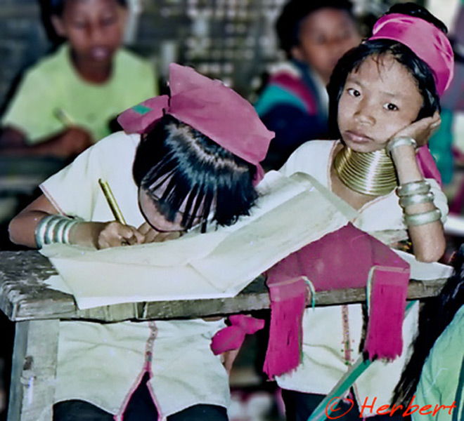
Location: Mae Hong Son, Thailand (19° 18′ 14″ N, 97° 58′ 38″ E)
Date: 13 August 1995; 2.10pm
Camera: (analogue) Olympus Mu on negatives and scanned
There is a sub-tribe of the Karen tribe living in the Kayah state in eastern Myanmar known as Padaung. They are more well-known as the “Long Neck” tribe as the women supposedly spot “long necks” (or giraffe women). They don’t actually have long necks – they wear rows of brass rings around their necks since young; these rings squash the vertebrae and collar bones as they grow older rather than stretching their necks. They also wear rings around their arms and legs. The reason that they do so is to look like a dragon- their ancestor. Legend has it that the Padaung people are the product of the impregnation by the wind of a beautiful long neck dragon. In Thailand, there are only a handful of Padaungs who are refugees fleeing the persecution by the Myanmese in the 1970’s. There live in the north, bordering Myanmar in villages which are dubbed “human zoo”. Such villages are set up as “tourist attractions” managed by Thais who also provide them protection. Tourists are brought to the village, paying an entrance fee, to see and photograph these ladies. There are allegations that the Padaungs are in fact imprisoned by the Thais that manage the villages and young girls are forced to adopt the ring tradition. While these may be so, the set up does provide the refugees a measure of certainty and protection from eviction (I am sure the “managers” are influential people) which they may not enjoy otherwise. Furthermore they do make a living from the visitors as well as selling whatever handicraft they made. I, personally cannot make a judgment if this is bad or otherwise.
August 25, 2010
The most crowded place in Mumbai on any weekends
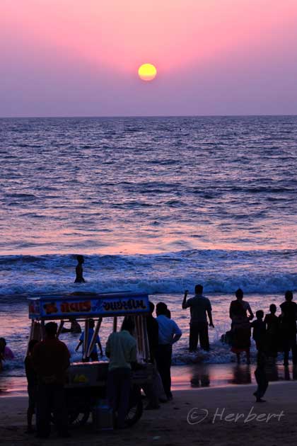
Location: Juhu Beach, Mumbai, India (19° 6′ 0″ N, 72° 49′ 48″ E)
Date: 17 April 2007 6.15pm
Camera: Canon 400D with Sigma 17-70/f2.8-4.5
Juhu is one of the most affluent suburbs of Mumbai where many of Bollywood’s stars live. It has a sprawling beach, Juhu Beach, which is very popular with Mumbai-ans. It is always jam-pack with people in the evenings and during weekends. The beach is actually pretty nice, facing the Arabian Sea, though the waves can be quite strong. There are many luxury hotels and apartments along the beach, especially at the southern end. There are also some exquisite shops and restaurants which are popular with the increasing number of young professionals, along the Juhu Road. It is probably the only beach in Mumbai that I will swim. It is also a fun place (for me) to watch people.
August 23, 2010
Special TV aerials to receive TV broadcasts, Melaka, Malaysia
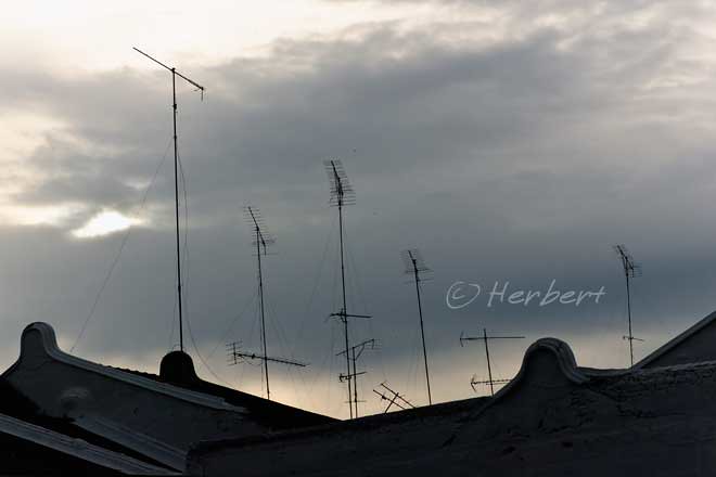
Location: Melaka, Malaysia (2° 12′ 0″ N, 102° 15′ 0″ E)
Date: 21 August 2010; 5.20pm
Camera: Canon 300D with kit lens
Melaka is one of Malaysia’s only 4 UNESCO Heritage Site and is the latest entry, together with Georgetown. I will deal with that in a later post. In towns south of Kuala Lumpur, one often sees tall aerials like these outside buildings. These special aerials are erected high above buildings so that the owners can receive TV broadcasts from far-away Singapore. Having such aerials give the owners access to (now) 6 more terrestrial channels on top of Malaysia’s own terrestrial channels without having to pay anything extra. This is quite attractive as Singapore’s programs are often newer than Malaysia’s. However one is likely to see less of such aerials as time goes by. These days in the age of satellite and cable TV’s, nearly all families in Malaysia subscribe to satellite TV. The contents of the such broadcasters are quite similar as they all offers the same few networks (at different prices between countries) such as ESPN, Star, HBO, BBC, Discovery etc.
August 20, 2010
The holiest shrine in Myanmar- the Shwedagon Pagoda, Rangoon
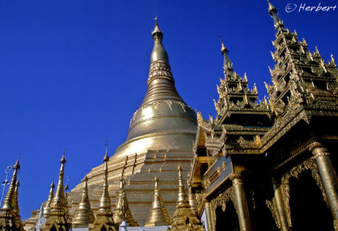
Location: Shwedagon Pagoda, Rangoon, Myanmar (16° 47′ 54.37″ N, 96° 8′ 58.07″ E)
Date: 11 December 2000; 5.15pm:
Canon EOS 500N (analogue) on slides and scanned
The cat is out of the bag, so to speak, as the Myanmar military junta has decided that the so-called general election will be held in November. It will not be much of a real election as the rules of the election are heavily biased towards the military to retain power, without the uniform. Even if the process does produce a non-military winner, it is doubtful that the winner is allowed to take over. Anyway most tourists including myself will try to avoid going to Myanmar closer to the election. I would love to revisit the country again soon as I really enjoyed my time there many years ago. The people are so incredibly friendly and hospitable and so eager to talk to foreigners. Some of Myanmar’s pagodas are just simply exquisite- like the holy Shwedagon Pagoda pictured here. I could imagine that much has changed as the country has opened up considerably since to foreign tourists. One thing for sure- we will not be forced to spend at least US$200 each; in the past foreigners must change US$200 into kyat at the airport and is not allowed to bring the kyat out or changed back to US$ on departing.
August 16, 2010
Xijiang, a quaint Miao village in the hills, Guizhou, China
Locations: Xijiang, Guizhou, China (26° 30' 0" N, 108° 11' 0"E)
Date: 26 April 2005; 10.35am
Camera: EOS 300D with kit lens
Xijiang is a beautiful Miao village amongst the many remote villages of different ethnic minorities in Eastern Guizhou. It has beautiful old Miao houses on stilts clinging to mountainsides with hundreds of rice terraces around the hills nearby. The Miaos are very friendly people and so do not be surprised that you are invited for some merrying and drinking during dinners. This village used to be rather remote and need many local connections to get there. However recently I saw some photos of the village being decked up and most if not all the houses were lighted up like X’mas trees at night. Furthermore there are also dance performances for visitors. I could only guess that the village have discovered the economic benefits of tourism and is now firmly gearing itself towards the package groups, both domestically and internationally. There is actually nothing wrong with this - in fact it is good for the village and its inhabitants if the major chunk of money generated goes back to them. But unfortunately this is not normally the case. Furthermore such packaged program is not really an authentic experience for those looking for one. I guess this is probably something that Lonely Planet (or at least one of its contributing authors) would never understand when it commented that “…sure, some villages have found tourism big time (and you’ll hear incessant grousing about it from travellers, as if they weren’t tourists too)… “ (p673 of the current issue of “China” guide). This is also precisely the reason that often-referenced sites on self-travelling in China have changed their focus.
August 13, 2010
The summit of K2 (Chogori) peeking out of the clouds
Location: K2 summit from Concordia, Pakistan (35° 44′ 0″ N, 76° 31′ 0″ E)
Date: 9 July 2007; 75.30am
Camera: Canon 400D with EF 70-200/f4 IS L
My trek to the K2 Base Camp 3 years ago was not as tough as I expected. The altitude was high but was not as exhaustive as I can remember compared to the trek to Everest Base Camp. I guess one reason is that we had porters for the K2/Concordia Trek- which anyone trekking to Concordia must, because of the lack of villages and supplies on the way- whereas I did then Khumbu trek to Gokyo and EBC all on my own i.e. carrying my own pack, without any porter or guide. Furthermore trekking alone in Khumbu, I could walk as far or as long as I like- and tend to do further/longer most days- while in group trekking, the distance walked each day is not as demanding. Regardless it is always a sense of achievement reaching the Base Camps.
August 11, 2010
Pumori above the “black rock”, Kala Pattar, Nepal
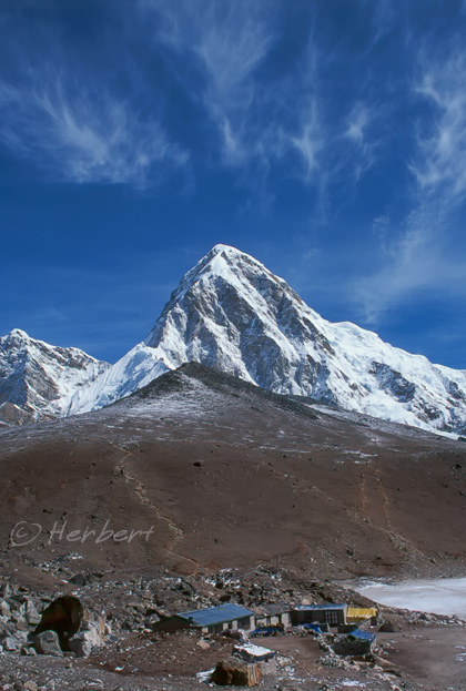
Location: GorakShep, Nepal (27° 59′ 45″ N, 86° 49′ 42.3″ E)
Date: 21 April 2000; 8.45am
Camera: Canon EOS 500N (analogue) on slides and scanned
Kala Pattar (meaning “black rock” in Hindi) is in fact a brown hump opposite the mighty giants of Everest, Lhotse and Nuptse in the Khumbu region of Nepal. It lies just below the south face of Pumori (7,165m). Kala Pattar is like a “must” for anyone who trek to the Everest Base Camp on the Nepali side; reason being the summit of Everest is not visible either from the base camp itself or from a lower base such as GorakShep. However the mountains are pretty spectacular from Kala Pattar- the best view is of course at the top. Most trekkers will first arrive at GorakShep – which are those huts in the picture- and ascend from the back of those huts. GorakShep itself WAS the original base camp during the days of Sir Edmund Hillary. It is now the last place any trekkers i.e. those without climbing permits, can stay overnight (not allowed to camp at Base Camp without climbing permits).
August 8, 2010
WuYiShan, one of 42 UNESCO Heritage Sites in China
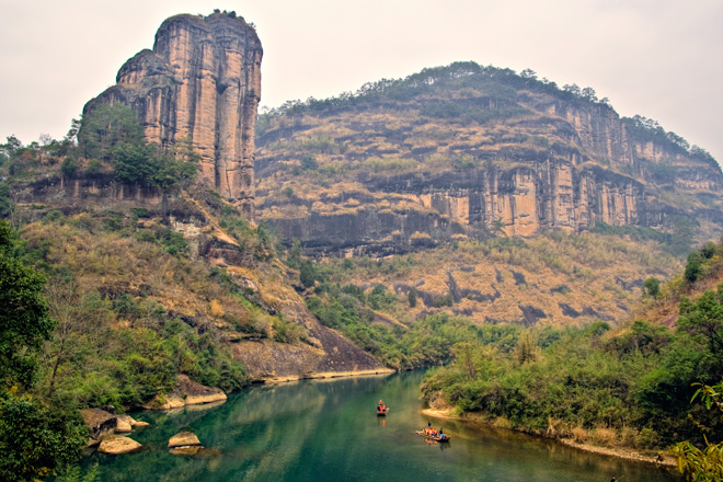
Location: WuyiShan, Fujian, China (27° 43′ 0″ N, 117° 41′ 0″ E)
Date: 5 December 2007, 9.15am
Camera: Canon 400D with Sigma 17-70/f2.8-4.5
China has just had 2 more entries into the UNESCO Heritage Sites List last week. It is fast catching up and very likely to have the most sites declared as UNESCO site soon- currently the highest number is Italy (45) followed by Spain (42) and China (40) according to the UNESCO Full List. I used to enjoy visiting such places in China as they are normally either places of extreme beauty or of tremendous cultural and historical significance (which is relevant to me as a Chinese). However in the last few years, I stop seeking them out as destinations of choice because I found that once a place became a UNESCO site in China, instead of being the peaceful and sublime places they used to be, they are marketed heavily domestically and regularly swamped by tourists. On top of that, invariably high entrance fees will be levied; this is fine if the collections go towards the site maintenance, but that is often not the case in China. What I find most abhorring is the commercial developments preceding some sites that are likely to be declared as a UNESCO Site; there have been reports that in some sites old dwellings were demolished and centuries-old livelihood destroyed to make way for spanky new commercial buildings in anticipation of the tourist traffic.
August 6, 2010
Seeing the land from the air on a hot air balloon, Goreme, Turkey
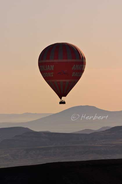
Location: Goreme, Cappadocia, Turkey (38° 40′ 0″ N, 34° 50′ 0″ E)
Date: 13 April 2010, 8.10am
Camera: Canon 400D with Canon 70-200/f4L USM
Cappadocia is a beautiful place- one of my favourite of Turkey. The landscape is amazing (will post more threads and photos) but the view is a little different from the sky on a hot air balloon- though I felt that it is over-hyped. Taking a hot air balloon ride in Cappadocia is like the “must-do” thing there; there are literally tens of such sight-seeing balloons in the air every morning and evening. All the operators offer more or less the same program- the main difference is the ride duration and the operator’s safety record. These operators target tourist groups and gear their services towards group. So “loose” tourists like us are only accommodated into whatever vacancies there may be on any balloon instead of the timing that we prefer.
July 31, 2010
July 30, 2010
Arrowtown, Otago, NZ, is only worth a visit in the autumn

Location: Arrowtown, South Island, New Zealand (44° 57′ 0″ S, 168° 50′ 0″ E)
Date: 24 May 2009, 3.10pm
Camera: Canon 400D with Sigma 17-70/f2.8-4.5
Arrowtown is an old gold mining town that has past its mining glory and more or less forgotten until about 20 years ago. Due to its proximity to the ever-popular Queenstown, it was discovered then, and since had become a favorite to package tour groups especially from Asia. The town is small and has some old buildings, which honestly are forgettable. The main street of old houses are refurbished and are now mainly shops selling souvenirs and so on. The only reason to go to Arrowtown is during autumn when the town is really beautiful with autumn glory. Otherwise don’t bother.
July 26, 2010
San Francisco’s famed cable cars

Location: Filimore Street, San Francisco, California, USA (37°48'18.18"N 122°25'31.58"W)
Date: 19 September 2006; 2.20pm
Camera: Canon Canon 300D with kit lens
3 things come to my mind when it comes to San Francisco (SanFran)- Silicon Valley, Golden Gate Bridge and Cable Cars. At first sight, it seems that the cable cars of SanFran are made for tourist, but in fact they are built as a matter of necessity. The streets of SanFran are so steep that it is often a struggle for smaller cars and a tram is not likely to be able to make it. That’s why cable cars are used for city transport. Currently there are 3 operating lines criss-crossing the city- they are a convenient and not-too-expensive means of transport. The cable cars are well-known as they are prominently featured in many movies which use SanFran as the setting.
July 21, 2010
Bungy jumping at Victoria Falls, Zimbabwe, Southern Africa
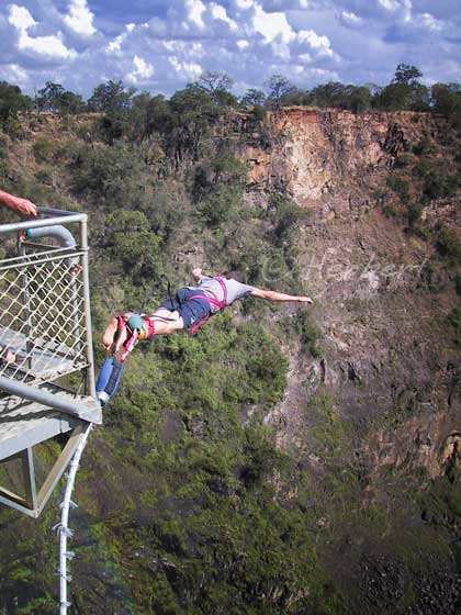
Location: Victoria Falls, Zimbabwe, Africa (17° 55′ 28″ S, 25° 51′ 24″ E)
Date: 5 April 2001; 4.20pm
Camera: (analogue) Canon 500N with slides and scanned
Bungy jumping had come a long way and is now such a common “adventure” activity that one sees such a set-up in most tourist spots that has a certain level of height such as rivers, lakes, bridges and buildings. It is quite an experience to jump off a bridge or whatever it may be. The moment of truth is actually when one stares out into the open space and height. It takes some courage for one to decide to leap. I have seen many people who wanted to try bungy jump to freeze when standing at the edge of the bungy platform and either have to be gently nudged or simply retreat to gather their courage for a jump at another time. In any case, bungy jumping is an experience that I would encourage. However if you do want to bungy, it is very important to do so with a reputed operator- it does not matter if it cost a little more- safety is of utmost importance.
July 19, 2010
Children eking out a living in the dry and poor district of Tingri, Tibet, China
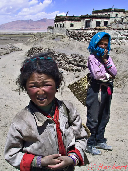
Location: Tingri Shekar, Tibet, China, (28° 34′ 0″ N, 86° 38′ 0″ E)
Date: 3 May 2003; 10.25am
Camera: Canon G1
Tingri Shekar is the main though small town on the Tingri Plains, situated approximately 60 km north-west of Mount Everest and just over 50 km from the Nepali border. The Plain is approximately 4,300 meters high and the air is always crisp. Sunrise is really pretty with the thin air bringing out the glows of the dawning sun. This town is frequented by climbers and expeditions to Cho Oyu, which looms across the horizon. It is a place of raw beauty. It is also one of the driest parts of Tibet, being behind the mighty Himalayas- the monsoon clouds dumped their rain when they cool ascending the height of the Himalayas. It is also very poor with little trade crossing this way. Things have changed a little in the last few years with more tourists coming this way to the Everest Base Camp or overland to Nepal. A few of the old houses in town had been rebuilt- a sure sign that things are a-changing. It may stay this way for a couple more years as there are no public transport connecting this place to other parts of Tibet yet. But don’t hold your breath- this is China after all. So if you still want to see a beautiful landscape relatively untouched by developments and still un-swamped by tourists in China, this is it.
July 15, 2010
Camel and riders at the Thar Desert of Rajasthan, India
Location: Camels & riders, Jaisalmer, Rajasthan, India (26.92oN, 70.9oE)
Date: 30 Dec 2008; 3.30pm
Camera: Canon 400D with Sigma 17-70/f2.8-4.5
A good friend of mine who have been to the Namib Desert of Namibia was terribly upset and disappointed with “the so-called dessert and camel rides” in Rajasthan. I thought it was humorous for her to expect the Thar Desert to be anything remotely close to the great sandy dunes of Africa. I supposed if the Tourism people of India and Rajasthan did not make such a big deal out of the “desert experience” of Rajasthan, tourists’ expectations will not be so high. Anyway I did not have high expectations when I did the so-called “camel safari” after hearing the feedback from my friend. So I was not disappointed. To me it was just a night out in the so-called desert.
July 12, 2010
Songbirds enjoy singing, naturally, Singapore
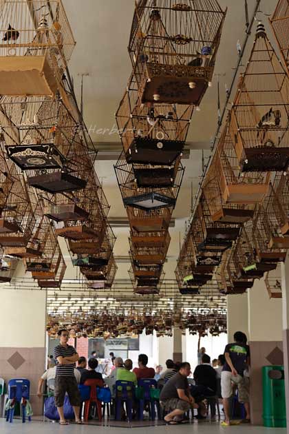
Location: Ang Mo Kio neighbourhood, Singapore (1° 22′ 12.6″ N, 103° 50′ 44.23″ E)
Date: 27 June 2010, 9.35am
Camera: Canon 400D with Sigma 17-70/f2.8-4.5
Despite its very modern facade, Singapore or more precisely Singaporeans still maintain many traditional habits and pastimes. One of them is enjoying bird singing. Every Sunday mornings, enthusiasts will gather at a few locations scattered around the island for their birds’ regular training. The owners arrive with their birds -merboks, China thrushes, white rumped shamas, red whiskered bulbuls and mata putehs (white eyes) - some costing hundreds of dollars, in carved lacquered teak cages. The owners will try to choose a hanger near other birds that will encourage them to sing at their best as it is the nature of songbirds to try outperforming one another in the attempt to attract the opposite sex. While the birds sing, the owners will exchange tips and news or just simply enjoy the “music”. It is believed that a bird’s diet influence how it sings; so a songbird’s diet may include any of the following- live insects, fruits and/or hard boiled eggs. These are very useful practice sessions for owners who are planning to enter their birds in bird singing competitions- National Competition carry a cash price of $10,000. It is not uncommon for winning birds to be traded for thousands of dollars. This is another of the non-mainstream activities (on top of those recommended here) that is highly recommended to visitors to Singapore. Any visitors who may like to experience this unique gathering should note that the busiest period of any Sunday is between 8.00 am and 10.00 am.
July 9, 2010
The ex-world’s tallest building, Petronas Twin Towers of Kuala Lumpur

Location: Petronas Twin Towers, Kuala Lumpur, Malaysia (3° 9′ 28.26″ N, 101° 42′ 41.94″ E)
Date: 2 July 2010, 8.55pm
Camera: Canon 400D with Sigma 17-70/f2.8-4.5
The Petronas Twin Towers of Malaysia may not be the tallest building in the world anymore (it is the 4th tallest now after the Burj Khalifa of Dubai, Taipei 101 of Taipei and Shanghai World Financial Center) but it is probably still the most spectacular and readily recognisable of all the world’s tallest buildings. It was the tallest building for 8 years until Taipei 101 was completed. Even though Malaysia is known for its beautiful islands, ancient forests, diverse culture and delicious food, the Twin Towers had become its most identifiable symbol since its completion in 1998. The building is brightly lighted every night and is visible from virtually any open space in Kuala Lumpur. Visitors can go up (free) to the skybridge joining the twin towers during daytime to enjoy the panoramic view. However patience is needed as there is always a long queue of people trying to do the same.
Technorati Tags: Kuala Lumpur,Petronas Twin Towers
The Grand Lady of Paris, Notre Dame de Paris
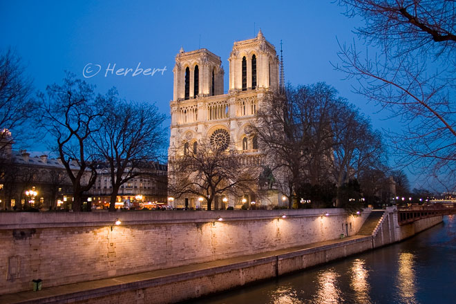
Location: Notre Dame de Paris, Paris, France, (48° 51′ 10.8″ N, 2° 20′ 59.28″ E)
Date: 28 February 2006; 7.30pm
Camera: Canon 300D with Sigma 70-200/f2.8
Notre Dame de Paris, Frecnh for Our Lady of Paris is more commonly referred to as simply the Notre Dame Cathedral is just one of many “Notre Dames” churches around the world. Most if not all of the Notre Dames are built in the Gothic style. The Notre Dame de Paris is one of the first Gothic cathedrals and perhaps the most beautiful of them all. It is also the seat of the Archbishop of Paris. It has beautiful carved walls and are adorned with many gargoyles. It is one of the more popular tourist destinations in Paris. Even if you do not have much interest in religions, it is an interesting building to admire.
July 7, 2010
A deal is done, the old-fashion way at Kashgar’s century old Sunday Bazaar
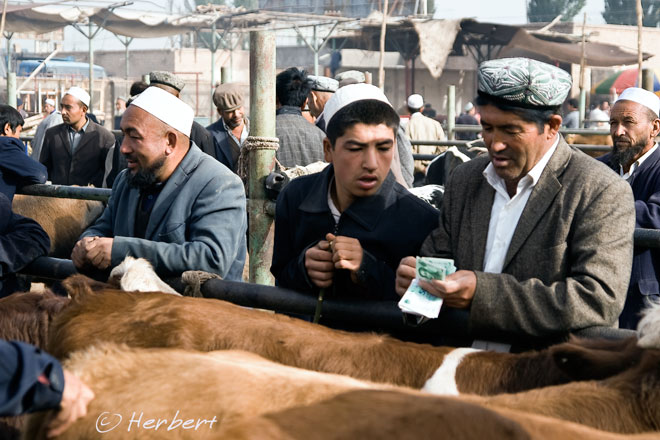
Location: Kashgar Sunday Bazaar, Xinjiang, China (39° 45' 26 N 78° 24' 18 E)
Date: 3 October 2008; 11.30am
Camera: Canon 400D with Sigma 17-70/f2.8-4.5
A couple of days ago, Xinjiang had its first anniversary of the deadly racial riots that rocked the province and China. An unfortunate and unavoidable consequence of the riots, in a country such as China, is a heavy clampdown on freedom and restrictions on movements of both foreigners and the ethnic population (Uighurs). By some accounts, internet access to many websites is heavily censored in the province- this is on top of the so-called “Great Firewall” restrictions on internet access generally in China. Activities and movements of the population are monitored around-the-clock by the installation of 40,000 CCTV cameras around Urumqi- reminiscent of the measures already in place around another troubled city, Lhasa. The Chinese government is pouring ever more money into the province for modernization in the hope that this will bring the whole province and population’s economic well-being to a notch closer to the rest of the country. To me, all these action are really missing the point. Xinjiang is already a wealthy province by all measures- it has the majority of China’s oil and gas as well as the land of “white gold” i.e. cotton. The problem is that all these wealth does not filter down to the masses and worst still, it is the Han Chinese who are enjoying the fruits. It is the same situation as in Tibet, with the ethnic people facing decimation vis-a-vis the migrant Hans. Top be fair, a lot of such difficulties faced by the Uighurs is not purposely perpetrated eg. it is not unnatural behaviour for Hans to employ someone from their own province instead of a Uighur. Furthermore some of the disadvantages faced by Uighurs is self-inflict eg. many of the Uighurs refused to learn Chinese and so could not get government jobs or employment by Han enterprises. That said, it is the prerogative of the Chinese government to address these very real issues head-on; sadly, they conveniently overlooked them and march on blindly with their prescriptions, hoping that money will resolve everything. This is just one dimension- there is also the complain that Uighur culture is being swamped by Chinese (the same complaint as in Tibet). The twin consequence of so-called accelerated economic development and the accompanied Chinese migration will definitely see the accelerated demise of century-old traditions in the province. Already Kashgar’s Old Quarters had all but gone; the Sunday Bazaar is just a shadow of its glorious past and may not survive much longer.
Subscribe to:
Posts (Atom)