June 28, 2010

The elusive Kawa Karpo peak of Meili Xueshan, Yunnan

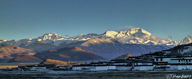
Locations: Feilaisi, Yunnan, China (28°29'44.27"N 98°54'9.21"E)
Date: 8 July 2004; 6.40am
Camera: Canon 300D with kit lens

Meili Xueshan is a subrange of the Hengduan Shan at the convergence of Tibet, Yunnan, Myanmar and Sichuan. The Meili range has more than 20 permanent snow peaks with at least 6 that are over 6,000m. Kawa Karpo (or Prince Peak) at 6,740m is the highest mountain of the range and in Yunnan. It is a holy mountain to the Tibetans- its importance is reinforced by the fact that of the 13 holy mountains, it is the only "male" mountain. Many Tibetans pilgrims come to circumambulate around the mountain on a 13-day kora- it will take us longer to do so. It is said that one has to be very lucky to even see Kawa Karpo as it is mostly shrouded in clouds. Many visitors to Yunnan venture as far as the so-called Shangri-la (old name Zhongdian) and go no further north. Whilst Shangri-la is a popular destination for many tourists as it was the place where most visitors would experience the Tibetan feel for the first time without going to Tibet ("was" because it no longer is due to Sino-isation of the town), it is really an unexciting place. Feilaisi is about 15 km outside another forgettable town, Deqin, which lies about 145km north of Shangri-la. This is where one should come to enjoy the mountain scenery in Yunnan, see the LancangJiang (Mekong River) and probably do some light trekking into the beautiful valley of Yubeng. Trust me- this is one journey that you will not regret going.


Read More...

June 25, 2010

Beware of money changers at most airports

Location: Suvarnabhumi Airport, Bangkok, Thailand (13° 40′ 52″ N, 100° 44′ 50″ E)
Date: 21 June 2010, 11.15am
Camera: Canon 400D with Canon 70-200/f4.0

Airports around the world are tourists’ traps of some sort. These days most of the airports are more friendly to budget travellers than the past and there are a lot more amenities for the budget-minded. Asian airports are leading the way in this respect and these days one can get free internet access in most Asian airports such as Singapore’s Changi and Bangkok’s Suvarnabhumi. However for the weary travellers, money changers in most airports still managed to trap them. The money changers in the majority of airports around the world- be it any of the Indian international airports or Atartuk Airport of Istanbul- still charge a hefty commission rate of up to 10% on any currency exchange that they transact. This is despite the fact that normally no such commission are charged for exchanges made in the cities proper. Unfortunately many travellers who are unprepared will have no choice but to change currency at the airport for immediate use such as transport and so on. So the smart travellers will always try to change some currencies of their destinations before-hand in their home country and NEVER do any currency exchange at the airport.

Read More...

June 23, 2010

Colourful Christian frescoes inside a cave, Goreme, Cappadocia, Turkey

Location: Frescoes in Elmali Kilise, Goreme Open Air Museum, Cappadocia, Turkey (38° 40′ 0″ N, 34° 50′ 0″ E)
Date: 11 April 2010, 11.20am
Camera: Canon 400D with Canon 70-200/f4L USM

Cappadocia is one of few places that I really enjoy in Turkey. Don’t get me wrong, Turkey is a fabulous destination to spend a few weeks- it has incredible history and heritage, beautiful coastline and an incredible atmosphere and culture, being at the crossroad between east and West. At some point, one feels like in Europe but most of the time feeling this is Asia with its population, Central Asia/Middle Eastern culture, practices and heritage. Well, the people look Middle Eastern anyway. It is precisely such familiarity (to me anyway) that I did not feel as excited as I should while travelling in Turkey. I am a person more inclined towards landscape, history and culture; in terms of landscape, I was not as fascinated as I was in some other countries. Cappadocia is the standout. Its unique natural wonders of moon-like landscape, fairy chimneys, underground cities, cave churches and houses carved in the rocks is just simply awesome and breathtaking. It is relatively inexpensive compared to the rest of Turkey and one can easily spend a week or so, just relaxing in the amazing landscape. Goreme in the centre of Cappadocia has some of the finest rock-cut churches, with beautiful and colourful Christian frescoes. Elmali Kilise (Apple Church) is one of the most beautiful and intact of the churches.

Read More...

June 21, 2010

Chiu Gompa face off with Mount Kailash, Tibet. China

Location: Chiu Gompa & Mount Kailash, Ngari, Tibet, China (30°45'55"N 81°22'5"E)
Date: 8 August 2007, 4.20am
Camera: Canon 400D with Canon 70-200/f4L USM

There are a few gompas surrounding Lake Manasarovar the source of the mighty Indus River (incidentally the name “India” is derived from the river). The most well-known of these gompas is Chiu Gompa which is situated in Chiu Village. It is often used by as an overnight stopover by trekkers participating in packaged trekking groups. The gompa, sitting atop a craggy hill, enjoys a fabulous vantage point overlooking the lake while Mount Kailash is visible over the distance to the north. In fact the gompa has one of the best locations in this region to view the two major reasons to visit this remote part of Tibet.

Read More...

June 19, 2010

Beautiful giant rice terraces of Yuanyang, Yunnan, China

Locations: Yuanyang, Yunnan, China (23° 9' 15 N 102° 44' 52 E)
Date: 27 February 2007; 4.10pm

Camera: Canon 300D with kit lens

Yuanyang is one of the most popular places for photography, at least amongst Chinese tourists, in China. They come here to photograph the beautiful rice terraces of the Yi minority. Thousands of photographers flock to this part of Yunnan every year especially during the pre-planting season when the terraces are filled with water. One of the reasons for its popularity is due to its easy accessibility from the provincial capital, Kunming. Normally photographers will wake up early in the morning, ride out to capture the sunrise. They then spend the daytime resting and trot out their gears again later in the day for sunset; sunrise around here is more spectacular. Few will venture out during the day and they miss out serene green sceneries as this photo. By the way, Yuanyang is just one of the few enigmatic locations for rice terrace photography in China. Parts of Guizhou such as Jinkeng are equally spectacular.

Read More...

June 17, 2010

The incredible camel racers of Bikaner Camel Festival, Rajasthan

Location: Camel racing, Bikaner, Rajasthan, India (28° 1′ 0″ N, 73° 18′ 43″ E)
Date: 11 Jan 2009; 5.10pm
Camera: Canon 400D with Sigma 17-70/f2.8-4.5

Bikaner is a small town in the amazing state of Rajasthan, with part of the Thar Desert within its boundary. Its claim to fame is its proximity to the incredible “Rat Temple” of Kami Mata at the nearby town of Deshnok. However its council had been trying to make a name for itself in the tourism map of Rajasthan and with some success. It have organised an annual “Camel Festival”, somewhat mimicking that of Pushkar. Unlike that of Pushkar, which is spontaneous and have religious significance, the festival of Bikaner is pure and simple, a top-down festival being run to attract tourists. Nonetheless it is a fun festival, normally running over 2 days with various events including a marvelous Camel Race. Man, those camels can really run- I have never seen or imagine camels can run that fast. It can be pandemonium at the race as the riders are not always capable of keeping the camels within the course; occasionally the camels ran outside the course and right into the crowds- which can cause fatal injuries.

Read More...

June 14, 2010

The farming scene in Five Rivers, NZ

Location: Five Rivers, South Island, New Zealand (45° 37' 0S 168° 26' 60E)
Date: 18 May 2009, 2.15pm
Camera: Canon 400D with Sigma 17-70/f2.8-4.5

NZ is really a pretty place to visit. It has a wide variety of landscapes (ranging from beautiful serene beaches, wetland forests to volcanoes and alpine mountains) and weather conditions in a small landmass. Most of the country is still relatively wild and untouched by human. This is a result of both a conscious effort by the people of the country to preserve the land and its relative isolation. The sparse population is also a factor; well, sparse population of human anyway. According to the latest statistics, NZ’s human population is about 4.7 million but has 32 million of sheep and 5.8 million of cows. The sheep-to-human ratio used to be at a staggering number of 20 to 1; though it is still high in the South Island where the human population is lower but with more extensive sheep farming. Most visitors to NZ will spend their time in places such as Queenstown and Te Anau; however the least visited places are normally the most scenic, such as this small farming town in Otago.

Technorati Tags: ,

Read More...

June 11, 2010

The world’s largest train station, the Grand Central Terminal, New York, USA

Location: Grand Central Terminal , New York City, USA (40° 45′ 10.08″ N, 73° 58′ 35.48″ W)
Date: 18 February 2006; 4.25pm
Camera: Canon 300D with kit lens

The Grand Central Terminal, more popularly referred to as simply, The Grand Central is a major landmark in New York. It has been made popular by appearance in innumerable movies and was one of the “must-go” places on my New York visit. It is supposedly the largest train station in the world by the number of platforms. It certainly does not feel that huge, compared to those of India and China. However I guessed the main reason for that is that the most visible part of the station is the concourse where the ticketing booths and cafes cafe located. The platforms and tracks are actually “hidden” away on different levels and by doors; whereas tracks and platforms in India are all visible. There are now so many buildings around the station that one can easily missed the station unless one specifically looks for it. These days, one of the most distinguishing sights in the station (concourse) is the huge American flag hanging from its ceiling- this was hung a few days after 9-11.

Read More...

June 8, 2010

Cho Oyu at dusk, outside Tingri, Tibet, China

Location : Cho Oyu from Tingri, Tibet, China (28° 34′ 0″ N, 86° 38′ 0″ E)
Date : 24 April 2003; 5.45am
Camera : Canon G1

Cho Oyu or jo bo dbu yag in Tibetan at 8,201m is the 6th highest mountain in the world. It is one of those giants that lie right at the border between Nepal and Tibet, China. Just like Everest or Qomolongma in Tibetan, expeditions to climb these mountains often start from both sides of the border. Cho Oyu is supposedly the easiest of the 8,000 metres Himalayan peaks to climb. The pass, Nangpa La, which lies a few kilometres west of the mountain used to serve as a main trading route between the Sherpas of Khumbu, Nepal and the Tibetans; and Tingri (4,300m) was a very important trading post for such traders. The Sherpas used to trade rice, grain and so on for Tibetan wool, livestock and salt. Today Tingri is still a small town of about 500 people but has a large PLA garrison/barrack at the edge of the town. No tourists will really go to Tingri unless they are on their way to the Everest Vase Camp or overland to Nepal. This will probably preserve the town's character a little longer but probably not for too long as an overland trip to the so-called Everest Base Camp (on the Chinese side ie the northeast face) is like part of any trips to Tibet.

Read More...

June 6, 2010

Terraces on the Dieng Plateau, Java, Indonesia

Location: Dieng Playeau, Central Java, Indonesia (7° 12′ 0″ S, 109° 54′ 0″ E)
Date: 19 December 1995; 5.20pm

Camera: (analogue) Canon EOS 500N on negatives and scanned

The Dieng Plateau is a plateau on the caldera floors of the Dieng Volcanic Complex in Central Java. The plateau is at a height of about 2,090m above sea level. It is well-known for its candhis, or Hindu temples, supposedly the earliest Hindu temples in Indonesia. This place is fresh as it is relatively high and can be quite chilly. It is often misty in the morning due to its height and the heat emitted from the volcanic ground around here. The journey up to this plateau is one of the prettiest in Java- all along there are small villages with layers and layers of rice and vegetables on terraces. Cultivation is plentiful in this region as the volcanic soil is extremely fertile. If you are making a visit to Central Java, to places such as Borobodur, Prambanan and Yogyakarta, it is worthwhile scheduling some time to visit this place.

Read More...

June 4, 2010

The “Smoke that Thunders” that is the Victoria Falls, Zimbabwe

Location: Victoria Falls, Zimbabwe, Africa (17° 55′ 28″ S, 25° 51′ 24″ E)
Date: 6 April 2001; 8.20am
Camera: (analogue) Canon 500N with slides and scanned

The Mosi-oa-Tunya (meaning “Smoke that Thunders”), better known as the Victoria Falls lies on the border between Zimbabwe and Zambia in southern Africa. The fall is neither the highest nor widest in the world; but it is claimed to be the largest sheet of falling water in the world by its measurement of 1,708m width and 108m height. The fall is formed when the calm waters of the Zambezi River plummets in a single vertical drop over its entire width. It is an amazing sight and sound as one gets close to the fall; in fact one can see the mists and sprays from the falling waters and hear the thundering noise from afar. The sprays can reach quite far on any windy days and it is advisable for any visitors to don a raincoat. However the best way to see the falls is from the air, on a helicopter- an expensive option. This is because from the ground level, one can only see a sheet of falling water without any of the majesty and presence of its depth and width.

Read More...

June 1, 2010

Ghandruk, in the shadows of the Annapurna mountains

Location: Ghandruk on Annapurna Circuit, Nepal (28° 29′ 24″ N, 83° 50′ 24″ E)
Date: 14 April 2000; 4.45pm
Camera: Canon EOS 500N (analogue) on slides and scanned

The Annapurna Circuit trek is one of the most popular trekking routes in Nepal. Every trekker who has done this circuit will know and probably remember this beautiful Gurung village in the shadows of the snowy peaks of the Annapurna and Machhapuchhere. At 2,012m it is inhabited by Gurungs, one of the many indigenous people of Nepal’s mountainous valleys. The Gurungs are more well-known overseas as they form a big bulk of the famous Gurkha soldiers, famed for their bravery and loyalty. Ghandruk is a quaint village with a very relaxed atmosphere and the major past-time (for most foreigners and trekkers anyway) is mountain-watching.

Technorati Tags: ,,

Read More...