


April 30, 2008
More wet temperate forest at Milford, New Zealand
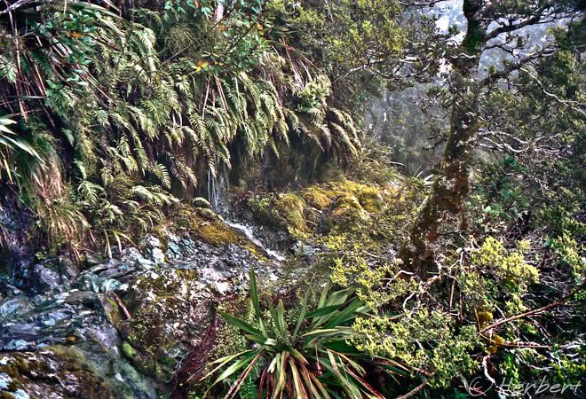
Location: Milford Track, South Island, New Zealand (44° 40' 60 S, 167° 54' 0 E)
Date: 22 December 1996; 1.20pm
Camera: (analogue) Canon EOS 500N on negatives and scanned
I have combed my collection of NZ photos -I lived there for 10 years- but could not find too many of the old analogs that looks good even after digital manipulation. Even those taken on my trek in Routeburn about 10 years ago could not make the mark- the weather was predominantly wretched during that trek. Only those on the Milford Trek are acceptable.
Southwest NZ which encompass the Fiordland National Park is one of the wettest places in the world and the rain contributes towards its beauty. Apart from tumbling waterfalls big and small (there are heaps of small ones in the Milford Track after rain), the rain nurtures a temperate rainforest of beech and countless ferns and all sorts of mosses. It is beauty that can only be appreciated by hardwork- trekking the forests.
Technorati Tags: Milford Trek,Milford Sound


April 28, 2008
Hiking at sunset at Palmwag, Namibia
Date: 18 April 2001; 7.15pm
Camera: (analogue) Canon 500N with slides and scanned
North of the Huab River in remote northwest Namibia is an arid landscape of seemingly nothingness but a road cutting through it. The area is divided up into large private concessions and Palmwag is one of them.
Palmwag is quite an amazing place teeming with all sorts of wildlife within the concession including the black rhino which the camp specialises in approaching on foot. However we were there specifically to look for desert elephants.
April 25, 2008
"Father of Glacier" Mt Muztagh Ata, Xinjiang, China
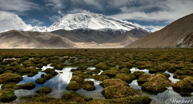
Location: Mount Muztagh Ata, Xinjiang, China (38° 16' 60 N 75° 7' 0 E)
Date: 9 June 2004; 4.43pm
Camera: Canon 300D with kit lens
Mount Muztagh Ata is 7,546m high, part of the Pamir Range in Xinjiang. It is permanently snow-capped with more than 10 glaciers tumbling down the slopes of the mountain; which earns it the nickname of "Father of Glaciers". It is one of the easiest 7,000m peak to climb.
It is a beautiful mountain with a pretty snow rounded summit. It is visible from the road between Kashgar and Pakistan (part of the Karakorum Highway). In fact it is one of the most beautiful peaks beside the huge and beautiful Karakul Lake (at 3,600m above sea level).
April 23, 2008
Angels and saints, Bidadari Cemetery, Singapore
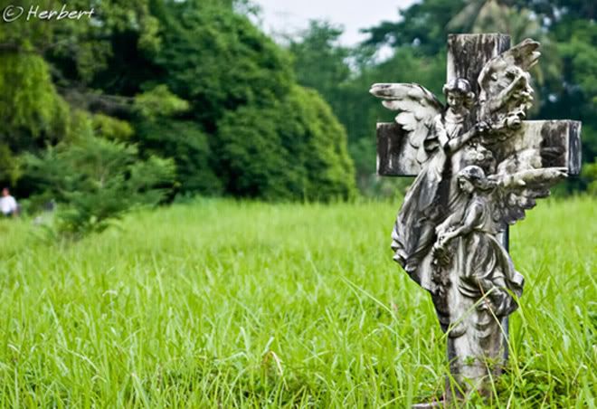
Location: Bidadari Cemetery, Singapore (1°20'18.77"N 103°52'15.06"E)
Date: 12 March 2004; 6.35pm
Camera: Canon 300D with EF50/f1.8 lens
Bidadari is a defunct cemetery in Singapore. It was Singapore's third cemetery, opening its doors on 1 January 1908 with sections for Muslims, Hindus, Singhalese and a large section for Christians of different denominations.
Like everything old and ancient in Singapore, it eventually succumbed to the voracious appetite for development and then simply disappeared. The cemetery was closed in 1973 and was slated to be redeveloped for public housing and other facilities. The exhumation of an estimated 143,000 graves was started in 2001 and completed by the end of 2006.
Bidadari used to have many elegantly carved tombstones especially in the Christian sections. Sculptured tombstones adorned with angels and saints were quite common sights.
April 21, 2008
Game for chess? Bastions park, Geneva
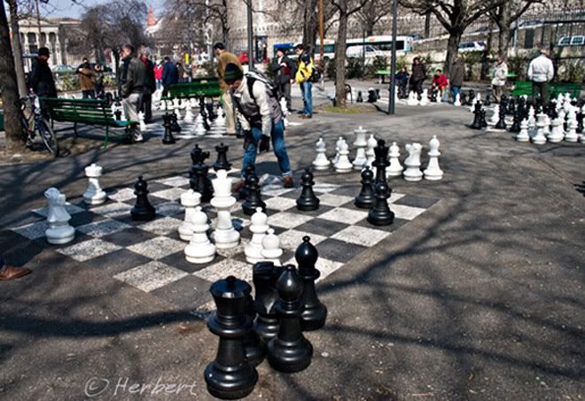
Location: Bastions Park, Place Neuve, Geneva, Switzerland (46°12'3.21"N 6° 8'36.03"E)
Date: 15 March 2005; 1.05pm
Camera: Canon 300D with kit lens
Bastions Park is the site of the first university in Geneva. The tree lined park is popular with students and is abuzz with activities all day round. At the north end of the park, there are sets of life size chess sets which attracts chess masters of all ages to challenge each other.
April 18, 2008
Borobudur, Java- the world's biggest Buddhist monument.
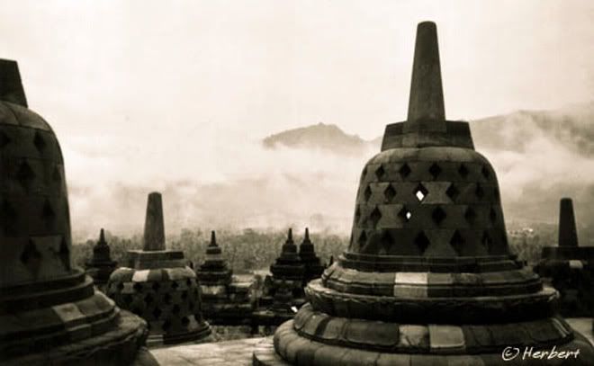
Location: Borobudur, Central Java, Indonesia (7° 36′ 28.8″ S, 110° 12′ 0″ E)
Date: 22 December 1995; 10.15am
Camera: (analogue) Canon EOS 500N on negatives and scanned
Borobudur is situated about 40 km northwest of Yogyakarta. It was built in the 9th century and is reputedly the largest Buddhist monument in the world. It is a nine level platform with thousands of relief panels and hundreds of Buddha statues. However the most distinguishing and recognisable image of Borobudur is perhaps the main dome located at the center of the top platform, which is surrounded by 72 Buddha statues seated inside perforated stupas as in this photo.
Travelling to Borobudur is quite straightforward from Yogyakarta as there are regular transport. There are also accommodation just outside of the park where the monument is located.
Technorati Tags: Borobudur,UNESCO Heritage Site
April 15, 2008
Sun setting behind USS Midway, San Diego, USA
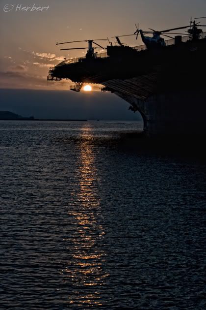
Location: USS Midway aircraft carrier, Bayfront San Diego, USA (N32 42 52.60 W117 10 23.63)
Date: 1 September 2006; 7.05pm
Camera: Canon 300D with kit lens
San Diego is well known for its Zoo and Water World and the nearby Disneyland . However there are impressive displays of American Naval history in the Maritime Museum and on the USS Midway aircraft carrier on the bayfront as well.
Technorati Tags: San Diego,USS Midway
April 13, 2008
Selling food in Bagan's ShweZigon Paya compound
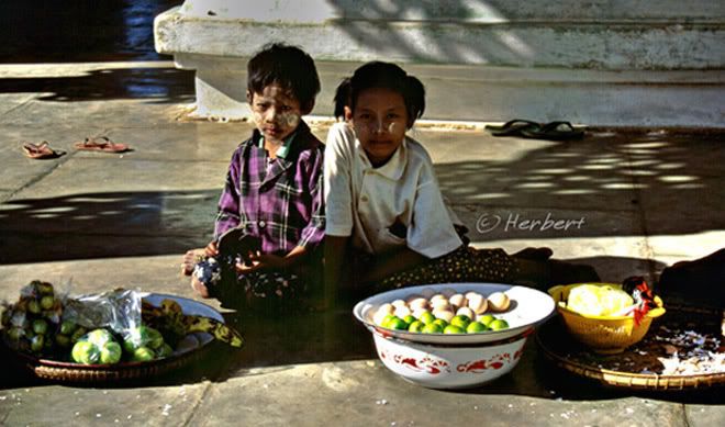
Location: ShweZigon Paya, Bagan, Myanmar (21°22′N 95°28′E)
Date: 16 December 2000; 2.15pm:
Canon EOS 500N (analogue) on slides and scanned
Bagan is an ancient capital of several Myanmar Kings and has an estimated 2,200 temple ruins that cover an area of about 42 square kilometres on the banks of Ayerwaddy River in central Myanmar. These temples were built between the 11th and 12th century. Many of the temples and stupas had been restored by the military junta abut they were done haphazardly ignoring original architectural styles and using modern materials. Furthermore the junta also built a golf course and a paved highway nearby. As a result despite its size and importance, it was not in UNESCO's Heritage site list as the temples were built in an un-historic manner.
Many of these temples are now being used again and often visited by pilgrims. One of the most important temples is the ShweZigon Paya as it serves a prototype for many stupas built across the country. As is common in most many temples, within the compounds of ShweZigon Paya, one can often see monks collecting alms as well as commoners selling food to visitors.
April 9, 2008
Natural Abraham Lincoln profile at Dear Cave, Mulu, Malaysia
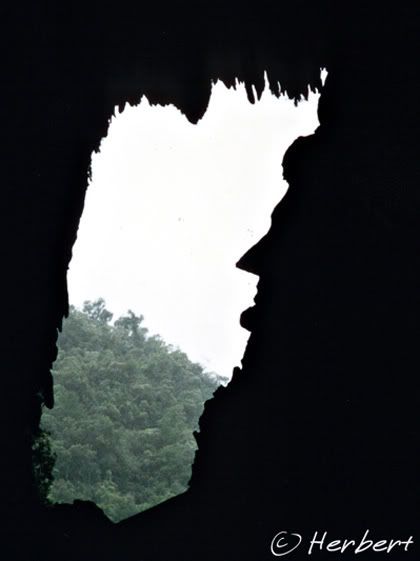
Location: Dear Cave, Gunung Mulu National Park(4° 3′ 0″ N, 114° 56′ 0″ E)
Date: 12 November1995; 3.20pm
Camera: (analogue) Canon EOS 500N on negatives and scanned
Dear Cave is one of the caves within the Gunung Mulu National Park situated in Sarawak, East Malaysia on Borneo Island. The National Park's enormous limestone outcroppings are littered with caves carved over millions of years by run-off from tropical downpours. Currently the most extensive cave system in the world is within the park. However the 300+ kilometres surveyed so far is suspected to be only a third of the passage that exists within the cave system. Within the park are few huge caves and karsts formations including the largest natural enclosed chamber, the Sarawak Chamber measuring 700m by 400m.
Even though most of the caves are for serious and well-equipped cavers only, there are accessible sections which are lit and tourists-friendly. The most popular caves are the well-lit and plank-walked Wind and Clearwater Caves. One of the most spectacular sights in the park is the blanketing of the evening sky by the exodus of millions of bats from the Deer Cave as they leave to look for food at sundown.
The Mulu Caves is rather inaccessible- the only practicable means is by flying to/from Miri. Otherwise it is a whole day ride on the river. It is much easier and probably cheaper to sign up for a package trip online or from Miri.
April 8, 2008
China ban matches and lighters on all domestic flights
China has banned matches and lighters on board all domestic flights with immediate effect. This is on top of the ban of liquids on all domestic flights since March. This is a security precaution as a result of a reported attempt to blow up a plane on a domestic route by a suspect by lighting drink cans of inflammable liquid.
April 6, 2008
Mosque with Chinese characteristics at Langmusi, Gansu
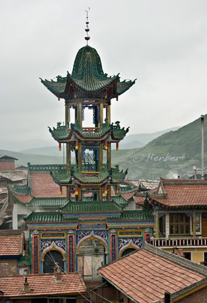
Location: Langmusi, Gansu, China (34° 5' 16 N 102° 37' 41 E)
Date: 28 June 2004; 10.05am
Camera: Canon 300D with kit lens
China has the 10th largest Muslim population in the world. Its Muslim population is mainly making up of ethnic Uighurs predominantly in Xinjiang and Hui (回族). The Hui are concentrated in the northwest and along the southern coast. The southern Hui are mainly descendants of mixed marriages between Arab and Persian Muslims with Chinese whereas the northern Hui are descendants of Mongolian, Turkic and Central Asian Muslims with Chinese. The Hui are culturally Han Chinese but practice Islam. The men can be distinguished as they wear white skullcap whereas ladies wear headscarves. Other than that they look very much like ordinary Han.
The Hui are so culturally Chinese that even architecturally their mosques do not look like mosques found in other countries; they look more like Chinese temples with the exception of the crescent moon spire.
April 3, 2008
Sun setting on Half Dome , Yosemite
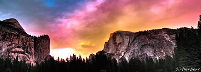
Location: Yosemite National Park, California, USA (37°43′18″N 119°38′47″W)
Date: 14 September 2006; 7.15pm
Camera: Canon IXUS IZoom
Yosemite is supposedly one oft he most popular national parks in USA. I guess one of the reasons is due to its easy access from the major population centres of California. I was surprised at how big the park is and how inconvenient trying to get around if one does not drive. It is quite unlike my experiences and perceptions of National Parks/Reserves elsewhere where there is really limited traffic and the only means to get around is by hiking or on boats; I supposed the size renders that impractical. Furthermore allowing traffic opens up the park's beauty to more people rather than only the fit and determined.
April 1, 2008
Lamas enjoying the sun at Tengboche Gompa, Nepal

Date: 11 May 2000; 7.45am
Camera: Canon EOS 500N(analogue) on slides and scanned
The Khumbu region is the home of the sherpa, who are of Tibetan ethnicity. Tengboche gompa is an important gompa/monastery to the sherpas and is the largest in the Khumbu region. It commands a panoramic view of the well-known peaks in the Himalaya such as Everest, Nuptse and Ama Dablam. The monks/lamas are also similar to those of Tibetan Buddhism.
The Everest trek is one of the most picturesque mountain scenery treks I have done. Apart from the scenery, there are also nice quaint villages to spend some days to chill out. However it can be challenging if one is not acclimatize sufficiently. Another reason that I enjoyed this trek was that I could do the whole trek (including Gokyo) without having to engage a guide or porter as this is a tea-house trek (one can stay and eat at the various tea-houses in the villages along the trek).
The Everest trek is one of the most picturesque mountain scenery treks I have done. Apart from the scenery, there are also nice quaint villages to spend some days to chill out. However it can be challenging if one is not acclimatize sufficiently. Another reason that I enjoyed this trek was that I could do the whole trek (including Gokyo) without having to engage a guide or porter as this is a tea-house trek (one can stay and eat at the various tea-houses in the villages along the trek).
Technorati Tags: Nepal, Everest, Tengboche gompa,Sagamartha National Park
Subscribe to:
Posts (Atom)