

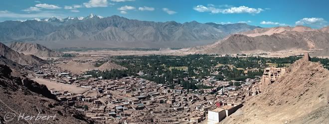
 Location: View from Victory Fort at Namgyal Hill, Leh, Ladakh, India (34° 10' 0 N 77° 34' 60 E)
Date: 28 August 1998; 2.20pm
Camera: (analogue) Canon 500N with negatives and scanned
Leh, the capital of the former Himalayan Kingdom of Ladakh, is now part of India, renamed Leh District and lies within the state of Jammu and Kashmir. It is part of the legendary disputed state of Kashmir, where wars were fought between India and Pakistan. Leh is largely Buddhists. Its inhabitants are mainly Tibetans as it used to be part of Greater Tibet in the old days.
Leh is only accessible by road during the summer months from Manali and Srinagar. The Manali-Leh road is the highest motor-able public road in the world crossing a few passes over 4,000m and two over 5,000m. It can also be reached by plane from Delhi.
The town is still mainly dotted by low-rise mud houses and retained its Tibetan/Himalayan charms. Leh is dominated by the Leh Palace, which was the former residence of its king. It has a few gompas, which will be of interest to those who have not been to Tibet, in the vicinity. There were very few foreigners when I visited the town back in 1998, cycling from Manali. Apparently it has not succumbed to the invasion of tourists and, happily, there are no McDonalds or Pizza Huts in town yet. However I suspect this absence has more to do with the protectionist attitude of the Indian government as a whole rather than being peculiar to Leh.
Technorati Tags: India,Leh,Jammu Kashmir,Ladakh


No comments:
Post a Comment